The David Rumsey Historical Map Collection has a great assortment of historical maps, including quite a few railroad maps. The interface to zoom in and pan is really well implemented and the maps listed below are wonderful visual references to the importance of railroading in the late 1800s and the turn of the century.
Showing posts with label U.S. Railroads. Show all posts
Friday, July 1, 2022
Sunday, April 10, 2022
Sunday, January 30, 2022
1884 map - illustrating Land Grants to Railroads
Wow!
From the David Rumsey Map Collection
Publisher: Rand, McNally & Co.
View Interactive map >
(pan and zoom)Thursday, October 8, 2020
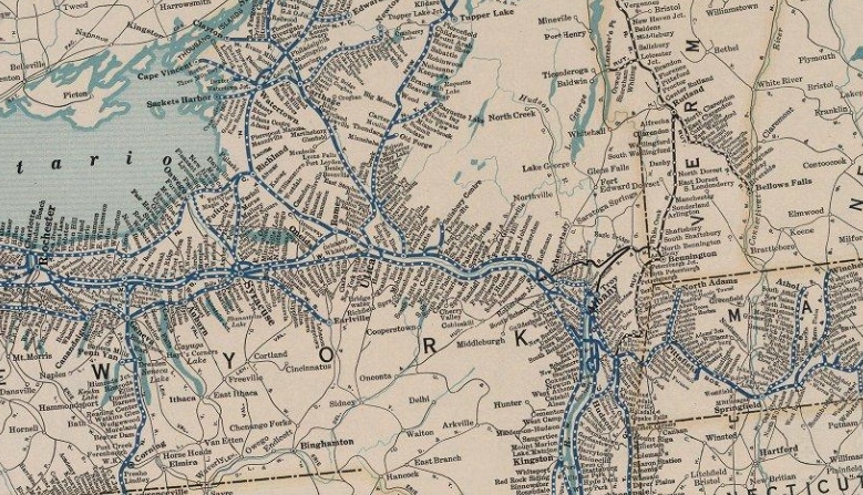
New York State Transportation Networks - 1800s
Sunday, August 9, 2020
More Railroad Maps
There's a wonderful site called Streamliner Memories that's filled with railroad memorabilia from the "Sliver Age" of streamliners. All types of Railroad Passenger Brochures, Dining Car Menus, Travel Advertisements can be found there.
These maps are screenshots of PDFs, Use the PDF link for higher resolution and/or downloading.
- Click on any map for an enlargement
- Click on the Source Link to view the PDF
![]() |
| The Chessie - 1960 (Chesapeake & Ohio RR) |
![]() |
| The Delaware & Hudson RR in the 1950s |
![]() |
| Northern Pacific (Red) - Burlington (Brown) 1957 |
![]() |
| New York Central - 1953 brochure Year-Round Travel Guide Source |
![]() |
| More from the NYC Travel Guide |
![]() |
| Union Pacific RR - 1966 |
Monday, June 29, 2020
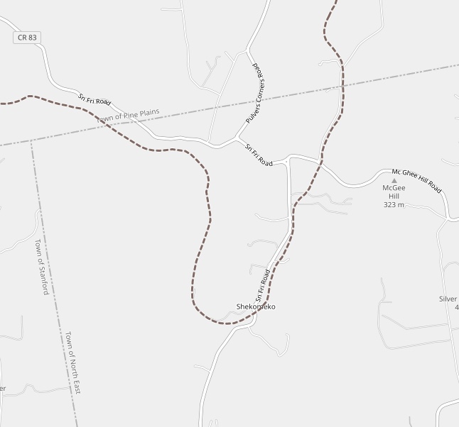
Shekomeko, New York
Shekomeko was a small historic hamlet in eastern Dutchess County, New York. Originally a village of Mahican Native Americans, the name Shekomeko was derived from their Algonquian language: she, -che (from mishe or k'che), 'great,' and comaco, 'house,' or 'enclosed place'—'the great lodge,', or 'the great village.'"
By 1746, area settlers petitioned the governor to issue to them a warrant authorizing the killing of Shekomeko Indians. Shortly thereafter the mission was abandoned and the ten remaining families--a mere 44 persons where all that remained of the original 8,000 member tribe 100 years before--sought refuge in nearby Connecticut, while others traveled to Pennsylvania to be closer to the established Moravian settlements there.
Sadly in 1925 the railroad line from Shekomeko east to Millerton was abandoned. Then in 1935, the line from Shekomeko west to Pine Plains was abandoned and by 1938, the entire railroad line was abandoned. Traces of the roadbed can still be found in places.
(The Little Nine Partners Historical Society)
Shekomeko:
The Mohican Village that Shaped the Moravian Missionary World
^ (excellent)
Shekomeko, New York (Wikipedia)
The Dutchess and Columbia Railroad
(The Little Nine Partners Historical Society)
History of the Moravian Church (Wikipedia)
(click on any graphic to enlarge)
Native Americans and the Moravian Mission
The village has a fascinating history. It was Moravian mission and in the summer 1742, Shekomeko was established as the first native Christian congregation in America. The increasing Moravian influence and their success with the Native Americans led to resentment by European settlers in the area. False rumors of atrocities were spread and the authorities were petitioned to intervene. A law was enacted on September 21, 1744 forbidding anyone from residing with Indians in order to Christianize them.![]() |
| Shekomeko village and Moravian mission, 1745 |
By 1746, area settlers petitioned the governor to issue to them a warrant authorizing the killing of Shekomeko Indians. Shortly thereafter the mission was abandoned and the ten remaining families--a mere 44 persons where all that remained of the original 8,000 member tribe 100 years before--sought refuge in nearby Connecticut, while others traveled to Pennsylvania to be closer to the established Moravian settlements there.
A Railroad is Built
Construction on the Dutchess and Columbia Railroad began in 1868, and by 1869 the line reached north to Pine Plains. Construction then continued eastward through Shekomeko reaching Millerton in 1871. In 1877 the railroad was reorganized as the Newburgh, Dutchess and Connecticut Railroad (ND&C). In 1905 the New York, New Haven and Hartford Railroad acquired the ND&C and in 1907 merged it into the Central New England Railway.
Click any image to enlarge it
Sadly in 1925 the railroad line from Shekomeko east to Millerton was abandoned. Then in 1935, the line from Shekomeko west to Pine Plains was abandoned and by 1938, the entire railroad line was abandoned. Traces of the roadbed can still be found in places.
Today
There's little left of the village now as this google aerial illustrates but there is a monument dedicated to the Moravian Christian Mission that was dedicated by the NY Moravian Historical Society in Oct 5, 1859.![]() |
| Photo Credit: WindingRoad |
Further Info
The Moravian Mission(The Little Nine Partners Historical Society)
Shekomeko:
The Mohican Village that Shaped the Moravian Missionary World
^ (excellent)
Shekomeko, New York (Wikipedia)
The Dutchess and Columbia Railroad
(The Little Nine Partners Historical Society)
History of the Moravian Church (Wikipedia)
Friday, May 3, 2019
The Growth of Railroads in the Capital District
Charting the history and explosive growth in this area through a chronological series of maps...
visit page >
Sunday, August 5, 2018
Catskill Mountain Narrow Gauge Railroads
Did you know there were narrow gauge railroads in the Catskills that operated for nearly forty years transporting vacationers up to the mountains. Its fascinating story and even includes an inclined railway the Otis Elevating Railway.
This Otis Elevating Railway was a cable funicular line that opened in 1892 and rose 1,630 ft up the mountain. in just 7,000 ft!
Further info will be forthcoming once a trek to the site is scheduled!
This Otis Elevating Railway was a cable funicular line that opened in 1892 and rose 1,630 ft up the mountain. in just 7,000 ft!
Further info will be forthcoming once a trek to the site is scheduled!
Railroad Maps of the Area
The Otis Elevating Railway
This was even featured in a Scientific American article on, Oct. 5, 1895!
Historical Railroad Map
Folks travelled by Steamer to either Kingston or Catskill and boarded a narrow gauge train to bring them to the mountain resorts,Elegant Hotels
At the top of the incline railway, there were a few very elegant hotels...
![]() |
| Catskill Mountain House |
![]() |
| Hotel Katerskill |
Further Info
- Otis Elevating Railway (Wikipedia) | Otis Elevating Railway (TrainWeb)
- Catskill Mountain Railway (Wikipedia)
- Catskill and Tannersville Railway (Wikipedia)
- Ulster and Delaware Railroad (Wikipedia)
Wednesday, April 4, 2018
Pequonnock Valley History
I have had a fascination for this park ever since I started mountain biking there ages ago with my son. Old abandoned mills, a rail trail full of history and magnificent scenery make every visit an enticing adventure.
Researching history thru old maps always brings little rewards of discovery. A remnant of an old path semi-obscured in the woods... the mystery behind an old foundation... discovering and learning their origins keeps me coming back for more :-)
RC Pedalpoint - Trumbull, CT
Mountain Biking at Pequonnock River Valley
Researching history thru old maps always brings little rewards of discovery. A remnant of an old path semi-obscured in the woods... the mystery behind an old foundation... discovering and learning their origins keeps me coming back for more :-)
Pathways to the former pond
| Remnants of an old road leading down to the railroad bed |
Old Mine Park
| Photo of Tungsten Mine (it ceased ceasing operations after a suspicious fire in 1916) |
Further Info
Pequonnock River ValleyRC Pedalpoint - Trumbull, CT
Mountain Biking at Pequonnock River Valley
Friday, August 18, 2017
Very Cool Interactive Map Exhibit
Mapping the Territory: Hudson County in Maps, 1840-2013
This exhibit featured maps of all varieties: topographical, infrastructure, transportation, sea level and birds-eye views. These maps showed how the region evolved geographically from forests, marshes and towering granite cliffs populated by Native Americans; to farms, settlements and villages built and inhabited by the Dutch, followed by the British and the newly independent Americans; and ultimately into the diverse, vibrant communities we live in today.
Zoom, Pan - very Cool
Thursday, February 9, 2017
Antique Railroad Maps
Curious about the United States railroad history? (I find it fascinating). Besides the motherlode of early USGS topographical maps provided by the University of New Hampshire, wardmaps.com, mapsofthepast.com and a few other sites have a variety of interactive scalable antique map viewers. Here’s a sampling…
Map of the New York Central Lines 1904
![]() |
| Viewer:http://www.wardmaps.com/viewasset.php?aid=21105 |
Railroad Maps of the United States 1848
39 State and Regional Maps
![]() |
Viewer:
|
Connecticut & Massachusetts & Rhode Island - 1925
![]() |
Viewer:
|
United States - 1916 (New England)
![]() |
Viewer:
|
Atlas of Railway Traffic Maps - 1922
by LaSalle Extension University - 15 maps
-1922-
Baltimore & Ohio Railroad
Santa Fe Railroad 1922
Burlington Route and Western Connections
Illinois Central Railroad and Other Eastern Lines
Southern Pacific Lines
Chicago Milwaukee & St. Paul Railroad
New York Central Railroad
Union Pacific System
Chicago & North Western Line
Pennsylvania Railroad System
Historic Railroad Maps
Atchison, Topeka and Santa Fe Railroad System
![]() |
| Viewer: http://www.mapsofthepast.com/old-railroad-maps |
Trolleys/ Interurbans
Map of The Street Railways of Connecticut - 1912
![]() |
Viewer:
|
Massachusetts Electric Railways - 1899
![]() |
Viewer:
|
Subscribe to:
Posts (Atom)