Showing posts with label First Nations. Show all posts

Friday, October 30, 2020

Native Lands (interactive map)

This is a fascinating Map

"View an online map that wipes away borders imposed by colonial powers to reveal a complex, colorful overlap of Indigenous territories, languages and treaties. Launched in 2015, the map draws on data from historic research, maps by Indigenous people, and ongoing input from people all over the world. Visitors can search for the roots of their own homelands and witness a view of the world that is almost never reflected on contemporary maps."

Native Lands - Interactive Map >

Note - it seems to not work with Chrome (try Firefox instead)


MapLab: Bearing Witness to Native Land

Related Article >

Friday, October 23, 2020

Native Americans - New England

Part 3 of an ongoing series on the history of Native American Territory as told through maps. This series is tagged as "Native American Map Series". It is recommended to visit all the Further info links listed below for further study.

Native Americans - New England

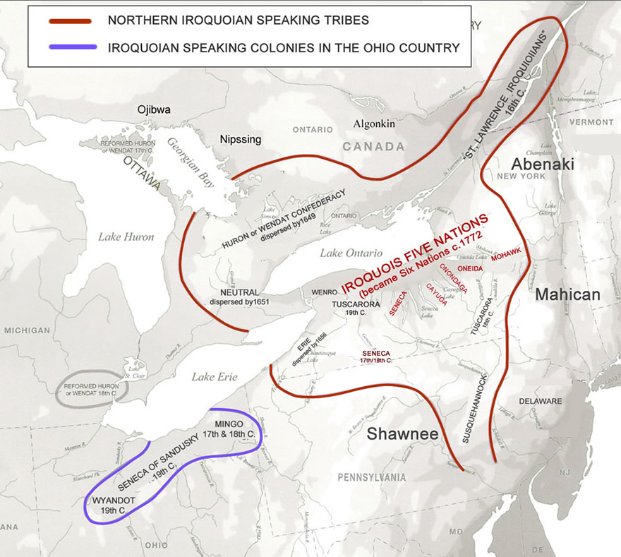
The indigenous tribes of the Northeast region of North America were among the first to have extended contact with European colonizers. Though members of numerous and separate tribes, the native people generally fell under the umbrella category of two main groups: Iroquoian and Algonquian. 

Source

Algonquian-speaking tribes lived primarily along the coast in socially and economically stable villages suited to fishing and farming. They were the larger of the two groups. Iroquoian-speaking tribes lived inland in smaller hamlets, near rivers and lakes, and relied on wild food. They tended to be warlike. 

Within both groups, a tribe consisted of several villages or hamlets joined in an alliance, called a confederacy. However, the stabilizing influence of these alliances provided no guarantee of peace among the tribes. Tribes within the Iroquois Confederacy would often raid others outside the protection of their alliance.

Native American settlements and trails in southern New England in the early 1600s
Source

Conflict

The arrival of Europeans and the subsequent spread of their colonies forced changes to the Native American ways of life and intensified the conflict between Iroquoian- and Algonquian-speaking groups. 

Perhaps the most troublesome of these was the concept of land ownership. To Europeans, ownership of land equated to wealth, and the New World seemed to offer unlimited possibilities to become land-rich. The native tribes, however, did not believe an individual could own land in this sense. Land could be used but not possessed, just as air might be used but not owned or kept. When Native Americans first shared the land with settlers, they did not understand that the settlers now would consider that land their property, would build fences, and would bar anyone else from using it.

All Texts Sourced From U.S. History/Northeast: 1620–1730


State-by-State Details

Thursday, October 22, 2020

Native American Conquest (Video Overviews)

Part 2 of an ongoing series on the history of Native American Territory as told through maps. This series is tagged as "Native American Map Series".

The two videos below do a great job of visually capturing the historical saga of Native American conquest and land loss.

European Conquest of the Americas

This is brilliant!  It should be a must read for all Americans!

This Land is My Land? 

The Legacy of Early Interactions Between Native Americans and Colonists

The British – who would later become the first “American citizens” – viewed the indigenous people as subordinate and uncivilized due to their nomadic lifestyles and “underutilization” of the land. Over a period of 300 years, from 1609 to 1900, Native American tribes went from inhabiting the entire land area, to living on specifically defined “native reservations.” Long before the founding of the United States, countless acres were taken through illegal treaties, trickery, and bloodshed.

These preliminary encounters between Native Americans and colonists laid the foundation for a tradition of land grabbing that repeated itself through the Revolutionary War of 1776, and especially later through policies of the United States federal government. Lest we forget: In the Americas, modern society was built on conquest, subordination murder and land-grabbing.


Wednesday, October 21, 2020

Indian (Native American) Territory

Western United States (Native American) Lands

This is the first introductory post of a upcoming series on the history of Native American Territory as told through maps. Forthcoming posts will be focused on a state-by-state basis whenever possible.  This series will be tagged as "Native American Map Series".

Note: All the David Ramsey Map Collection links will take you to an zoomable detailed version - it is highly recommended to use all these links provided for further study.

Northwest 1845 
David Ramsey Map Collection
US Population 1870
David Ramsey Map Collection
Southwest Tribal Lands
United States EPA
Southwest Indian
History, Tribes, Culture, & Facts
Britannica

Monday, May 11, 2015

This Land Was Theirs...

Native American History in the Hudson and Mohawk Valleys

An overview of Native America history starting from colonial times until the present told primarily through maps. Focus is on upstate New York.


Take a fascinating journey back in time and learn many new lesser known details about the conflicts and transformation that took place.

 Map Collection >


Sunday, April 12, 2015

Ballston Lake - Native American Trails

Did You Know?  

Ballston Lake, NY has long been recognized as being on the trail leading from the Mohawk River at Rexford/Alplaus, north along the Alplaus Creek to the lake and thence north and northeast to Saratoga Lake and the Hudson Valley (see map below). Also, further travel east up the Hoosick Valley is known to have existed, which provided a means of entry into New England.


Stone Hearths, Shelter Remnants, Shell Refuse Pits, Flint Points and Ceramic Pottery Fragments were found at the Seman site and documented in this Massachusetts Archaelogical Society Bulletin in 1965. Link  > (PDF )

These trails provided Native American tribes at least one means of contact with New England from the Ballston Lake area. By this route, as well as others no doubt, ideas are thought to have flowed in an easterly direction.

Glacial Origins
As detailed on this page > (Scroll to 4 - East Line Turn to see map of the Ballston Lake-Round Lake Channel), geologically, Ballston Lake is a part of the remains of the early post-glacial Mohawk River.  Later it was diverted to its present course to the Hudson River through the Aqueduct Cliffs at Rexford, New York.

Tuesday, April 7, 2015

16th Century Iroquois Sites in Upstate New York

Reports on three important villages of the Mohawk tribe, the easternmost of the five historically known tribes that comprised the famed League of the Iroquois. The Mohawk tribe occupied the area between the modern village of Little Falls and the city of Amsterdam. This tribal territory was approximately 40 miles wide from east to west and 20 miles wide from north to south.


Why Were These Sites Chosen By The Mohawk?

The Garoga, Klock, and Smith-Pagerie sites are all located in Ephratah Township, Fulton County, New York. They are situated on high, easily defended ridges in the drainage of Caroga Creek, a major tributary of the Mohawk River.

The processes of erosion, and glacial infilling formed the ancient down-cutting streambed of Caroga Creek (similar to a number of other stream beds that dissect the valley). These drainage systems carried massive amounts of water down the valley floor. Over tens of thousands of years, these streams deeply incised the soft underlying sedimentary bedrock creating narrow and deep gorges or “hollows”

The highly developed series of meanders that characterized these tributaries created numerous isolated oxbows and ridges protected on three sides by stream-cut cliffs and embankments. Thousands of years after retreat of the Wisconsinan ice, which took place around 12,000 years ago, these elevated and isolated locations were sought after by the Mohawk Iroquois for the natural defenses they provided.  

Maps


Techniques for Uncovering and Understanding Native American Vestiges

Post Molds - The most common technique for investigating the archaeological remains of longhouses is by exposing post-mold patterns either by mechanical stripping or hand excavation. Post molds are the filled voids in the ground created by past structural elements long since removed, burned, or rotted away. Usually circular on the exposed surface and tapering or conical in cross-section, they are often only recognizable through careful identification of differences in soil color and texture defining the outline of the mold.

Magnetometry, a relatively new technique used by the Mohawk Valley Project, has proven to be useful for site investigations in some instances. Under certain conditions a magnetometer can locate fired clay features, such as hearths, because they create a subtle distortion in the magnetic field. Comprehensive survey of a site taking magnetometer readings at regular intervals can be used to produce a shaded contour plot depicting magnetic anomalies. These anomalies can then be tested in the field using soil auguring to verify the presence or absence of hearths. Because longhouses were typified by fire hearths located along the central aisle, identification of a linear pattern of hearths often indicates the presence of a longhouse.

 - Source -

NEW YORK STATE MUSEUM BULLETIN 503
by Robert E. Funk and Robert D. Kuhn
2003


Thursday, April 25, 2013

Native Americas (First Nations) - Visual Quick Study

- Click on any map for an enlarged version -

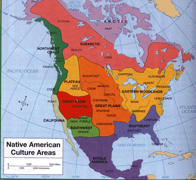
Native American Cultural Areas

North American - Native Language Groups

1600s


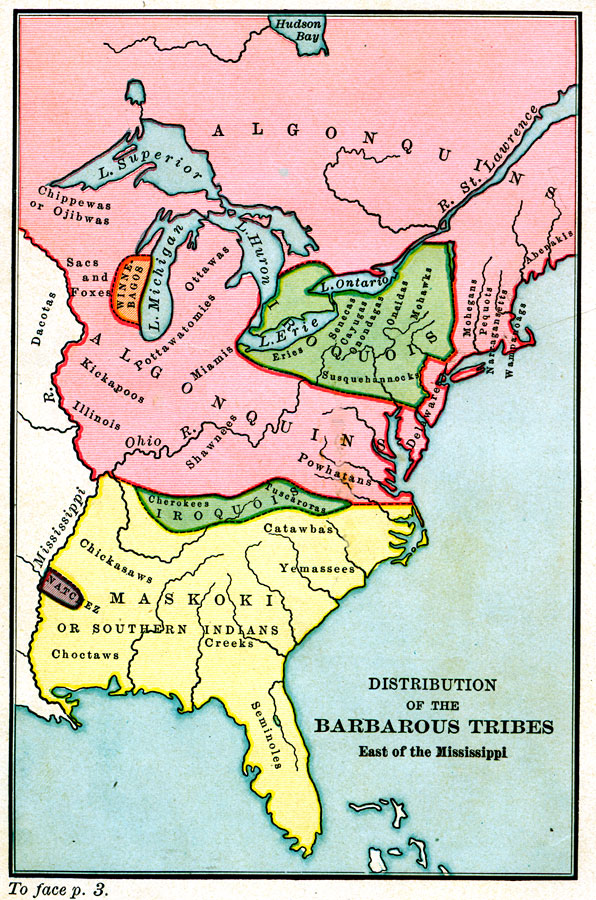
Distribution of the "Barbarous" Tribes East of the Mississippi    1491
A map of the Native American families and groups in North America east of the Mississippi River circa 1491. 

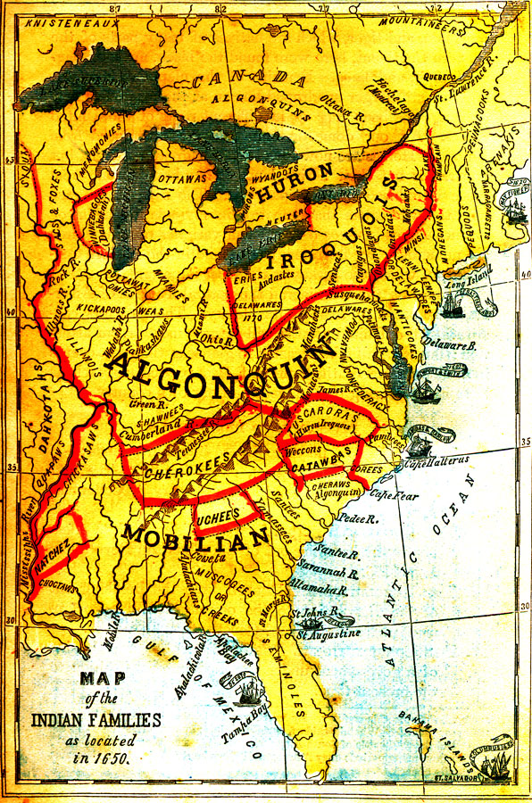
Map of the Indian Families, 1650
A map of the Native American families and groups in North America east of the Mississippi River as located in 1650. 

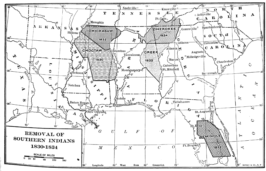
Removal of Southern Indians, 1830 to 1834

Forced Migrations


Native American Study 

  • Sad saga of deceit by U.S. government replete with colorful maps of Native North American Languages and the Trail of Tears   --  Recommended Reading >