Indian tribes, reservations and settlements in the United States
1939 - Library of Congress Geography and Map Division

View Interactive Map >
(Zoom and Pan)
(Zoom and Pan)
Indian tribes, reservations and settlements in the United States
1939 - Library of Congress Geography and Map Division
No matter where you may venture to in the U.S. -- it seems you can find tribute/evidence of native American origins if you know where to look...
The Native Americans of the present-day Glastonbury/Portland area were members of Algonkian-speaking tribes. They lived in clans of approximately 100 individuals and each group was ruled by a sachem or chief. Clans took names from features of the land where they were centered. Naubucs lived in the plains to the east, the flat area at the north end of town. Nayaugs lived a bit further south near the Noisy Water at the mouth of Roaring Brook (note: they were also known as the Red Hill Indians). Wangonks lived at the bend in the river behind today’s Town Hall, where the Connecticut River turned in the 1600s. The Neipsic springs first attracted Native Americans who came for the water's mystical healing powers. Today, the water still bubbles up from the hillsides in Glastonbury's J.B. Williams Park found on Neipsic Road.
The tribes were peaceful and farmed the land. In the summer, clans lived along the river in longhouses. In winter, they moved to the hills and lived in south- or west-facing caves.


For roughly 12,000 years, Indigenous peoples have lived where we now call "New Hampshire." The Abenaki tribe (together with the Maliseet, Passamaquoddy, Mi'kmaq, and Penobscot Indians), were members of the old Wabanaki Confederacy, adversaries of the Iroquois. These allies from the eastern seaboard spoke related languages, and Abenaki and Wabanaki have the same Algonquian root, meaning "people from the east."
The original inhabitants of the area that is now New Hampshire:
 |
| Source |
There were three important subdivisions of the Abenaki tribe: the Sokoki (or Sokokis), the Cowasuck (Cowass or Coos), and the Missisquoi (or Mazipskwik.)

Although there is no local reservation or population center for the Native Americans, their names endure as names for modern-day cities, mountains and rivers:
The lands of Rhode Island in the 1600s were mainly inhabited by three Native American tribes. To the east of the Narragansett Bay and the Providence River were the Wampanoags. On the south coast were the Eastern Niantics. The majority of Rhode Island was occupied by the Narragansetts.
The Narragansetts, in 1600, numbered around 4,000. Roger Williams settled among them and, through their favor, was able to found what became the Rhode Island colony in Providence. Although the colonists had peaceful relations with the Narragansetts, by 1675, the number of colonists had grown, pushing the Native Americans to the West. Indian land was seized at fwrfare erupted. Outnumbered and subsequently defeated, the power of the Native American tribes of southern New England was destroyed.
Many male Native American survivors were sold into slavery in the West Indies, while women and children were enslaved in New England. Remaining Narragansetts left the area and now the remainder of the tribe is living near Charlestown. Today, the Narragansetts are the only federally recognized Native American tribe in Rhode Island. Sourced from Native Americans shaped Rhode Island’s history
The original inhabitants of the area that is now Rhode Island:
 |
| Source |
 |
| Source |
Early Contacts with Europeans
Prior to the well known Pilgrim arrival in 1620, the indigenous population had numerous contacts with European explores along the coast. Starting in 1602, trading with the Wampanoag and camps on Cape Cod were established.In 1605, French explorers led by Samuel de Champlain explored the Massachusetts coast. In 1605, French explorers led by Samuel de Champlain explored the Massachusetts coast and marveled at the abundant crops of corn, beans, squash, tobacco being cultivated by the Natives.
Disease
Between 1616 and 1619, it is estimated that at least three fourths of the Indian population in Massachusetts died from European epidemic diseases. Some authorities estimate the death toll at 90%.
The Pilgrims
When the Pilgrims arrived in 1620, they encountered few living people but saw evidence of many Indian graves.
Tribal Areas
The original inhabitants of the area that is now Massachusetts:
 |
| Source |
 |
| Source |
 |
| Source |
"Europeans first arrived in the Gulf of Maine in a series of exploratory voyages lasting roughly from 1524 to 1613. During this century of exploration, three themes emerged with lasting significance for the history of Maine.
- First, in almost every instance, initial relations between English and Indian deteriorated quickly from friendship to suspicion and hostility, suggesting a deep flaw in English diplomatic approaches.
- Second, these early voyages projected a false and ultimately dangerous impression of Maine as a New-World paradise where little work would yield great wealth.
- Third, they laid the basis for overlapping French and English claims to the Wabanaki homeland that precipitated a three-way struggle for supremacy or survival that lasted for another century. These themes – diplomatic failure, false expectations, and imperial claims – explain much about Maine's marginal status as a proprietary colony and later as a province of Massachusetts." Source

"Plagues that swept through the Indian villages beginning in 1616, killing more than 75 percent of the inhabitants and leaving the rest weakened culturally, spiritually, economically, and militarily. By the middle of the 17th century the Abenaki were living in a nightmarish landscape shaped by conflict, disease, and alcohol, and they turned to the missionaries for help and reassurance."
Summary
Between the late 17th century and the early 19th century, Great Britain, France, and others in Europe engaged in nearly constant warfare. The battles for economic and political power spilled into North America, catching the native populations in the middle. By the time a lasting peace came between France and Britain, European descendants had permanent settlements in North America and the native populations were relegated to the fringes. Source
 |
| Source |
 |
| Source |
 |
| Source |
The Abenaki (also spelled Abnaki or Wabanaki) were an Algonquian-speaking North American Indian tribe that united with other tribes in the 17th century to furnish mutual protection against the Iroquois Confederacy. The name refers to their location “toward the dawn.” In its earliest known form, the Abenaki Confederacy consisted of tribes or bands living east and northeast of present-day New York state, and later the confederacy included some tribes as far south as present-day Delaware. Source
There were three important subdivisions of the Abenaki tribe: the Sokoki (or Sokokis), the Cowasuck (Cowass or Coos), and the Missisquoi (or Mazipskwik.)

Update:
The Nulhegan Band of the Coosuk Abenaki Nation is nestled in N’dakinna (our homeland), the present-day Northeast Kingdom of Vermont. The tribal headquarters are located in Barton, Vermont.
As this Wikipedia page illustrates, there are quite a few places in Connecticut that have names of Native American origin:
 |
| Iroquois | Algonquian |
 |
| Map of Connecticut, circa 1625 Indian trails, villages, sachemdoms > |
 |
| Wikipedia |
 |
| Connecticut - American Indian Reservations > |
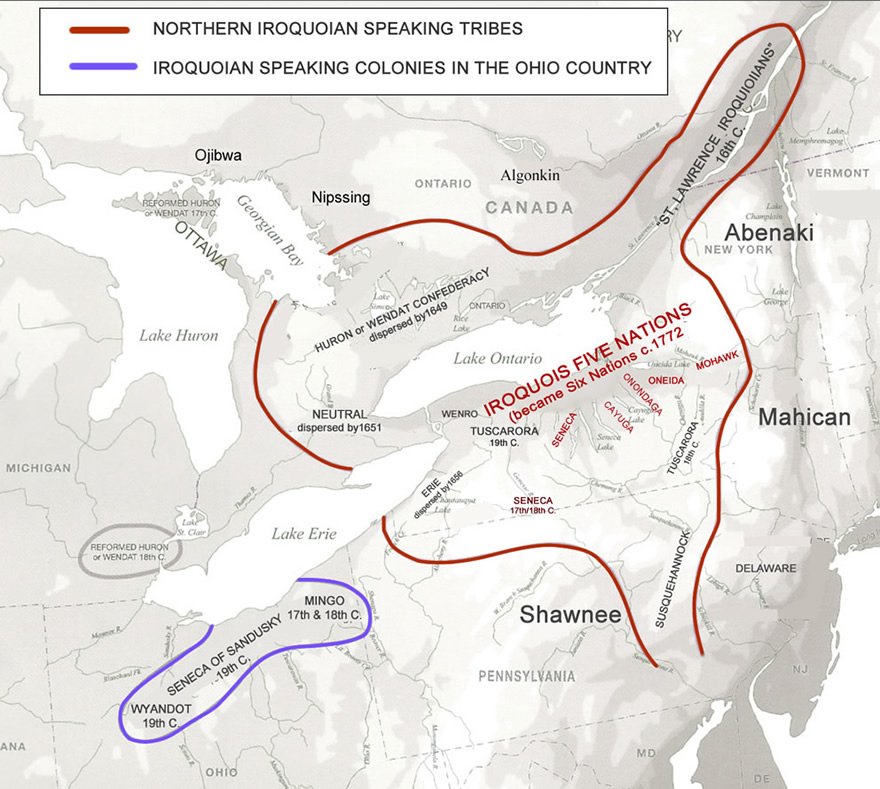
The indigenous tribes of the Northeast region of North America were among the first to have extended contact with European colonizers. Though members of numerous and separate tribes, the native people generally fell under the umbrella category of two main groups: Iroquoian and Algonquian.
 |
| Source |
 |
| Source |
The arrival of Europeans and the subsequent spread of their colonies forced changes to the Native American ways of life and intensified the conflict between Iroquoian- and Algonquian-speaking groups.
Perhaps the most troublesome of these was the concept of land ownership. To Europeans, ownership of land equated to wealth, and the New World seemed to offer unlimited possibilities to become land-rich. The native tribes, however, did not believe an individual could own land in this sense. Land could be used but not possessed, just as air might be used but not owned or kept. When Native Americans first shared the land with settlers, they did not understand that the settlers now would consider that land their property, would build fences, and would bar anyone else from using it.
All Texts Sourced From U.S. History/Northeast: 1620–1730
Native American Map Series
The two videos below do a great job of visually capturing the historical saga of Native American conquest and land loss.

This is the first introductory post of a upcoming series on the history of Native American Territory as told through maps. Forthcoming posts will be focused on a state-by-state basis whenever possible. This series will be tagged as "Native American Map Series".
Note: All the David Ramsey Map Collection links will take you to an zoomable detailed version - it is highly recommended to use all these links provided for further study.
 |
| Northwest 1845 David Ramsey Map Collection |
 |
| US Population 1870 David Ramsey Map Collection |
 |
| Southwest Tribal Lands United States EPA |
 |
| Southwest Indian History, Tribes, Culture, & Facts Britannica |


 |
| David Rumsey Historical Map Collection |
 |
| David Rumsey Historical Map Collection |
 |
| David Rumsey Historical Map Collection |
 |
| David Rumsey Historical Map Collection |
 |
| Location - Google Maps |
 |
Historic Marker |
 |
| By Dmadeo - Own work, CC BY-SA 4.0, |