Showing posts with label Historical. Show all posts

Monday, August 8, 2022

Scribner's 1883 USA statistical atlas

Scribner's statistical atlas of the United States, showing by graphic methods their present condition and their political, social and industrial development. Amazing maps, infographics, etc. from 1880!

A random sampling...

Presidential Election History
Image 36


Irish
Image 79

Insane and Idiotic 
Image 91

Illiteracy
Image 111


Interactive Atlas >
Library of Congress Geography and Map Division


Sunday, November 1, 2020

NYC - Antique Maps

 Interest zoomable/pannable antique maps of New York City

Original 1859 Topography of Manhattan Island

This map, compiled from old Surveys and records, was intended to exhibit the general localities of the original drainage streams, without defining the precise points at which they would intersect the Streets and Avenues in 1859.
Author: Viele, Egbert L. - Date: 1859   View Interactive map at David Rumsey.com >

NYC - Battery to 80th St. -1859


Topographical Map of the City of New York 1865

The map shows all the original water courses of Manhattan Island, with the street grid superimposed on top. Three different kinds of land are shown: Marsh, Made Land, and Meadow.
Author: Viele, Egbert L. - Date: 1865.  View Interactive map at David Rumsey.com >

NYC Topo 1865

An aerial illustrated view of New York City 1931

1931 illustrated map  showing city blocks, streets, roads, railways, landmarks, buildings, parks, etc. Includes note on Rapid Transit facilities. Copyright Herald Square Hotel. 
Author: Herald Square Hotel Date: 1931 View Interactive map at David Rumsey.com >

NYC Aerial View - 1931

Friday, December 18, 2015

American History - YouTube Gems

Gems? There were only a couple that qualified: short and based on map animations.

American History in 60 seconds


Expansion of the United States Map 1763 - Present


Friday, July 3, 2015

Caucasus (Part One)

I just finished reading the dense but well-written book on the history of the Caucasus: The Ghost of Freedom: A History of the Caucasus by Charles King  
It is a fascinating yet complicated region and truthfully--because of the multitudes of languages, ethnic groups and ever-shfting allegiances--the book was hard to follow. Nevertheless I still would recommended it. The region has been cast as an untamed exotic place, filled with mysterious intrigue and dangerous allure and its history justifies that description.

Maps--as always-will help visually simplify the vast variety of diversity that gives this region its unique character.

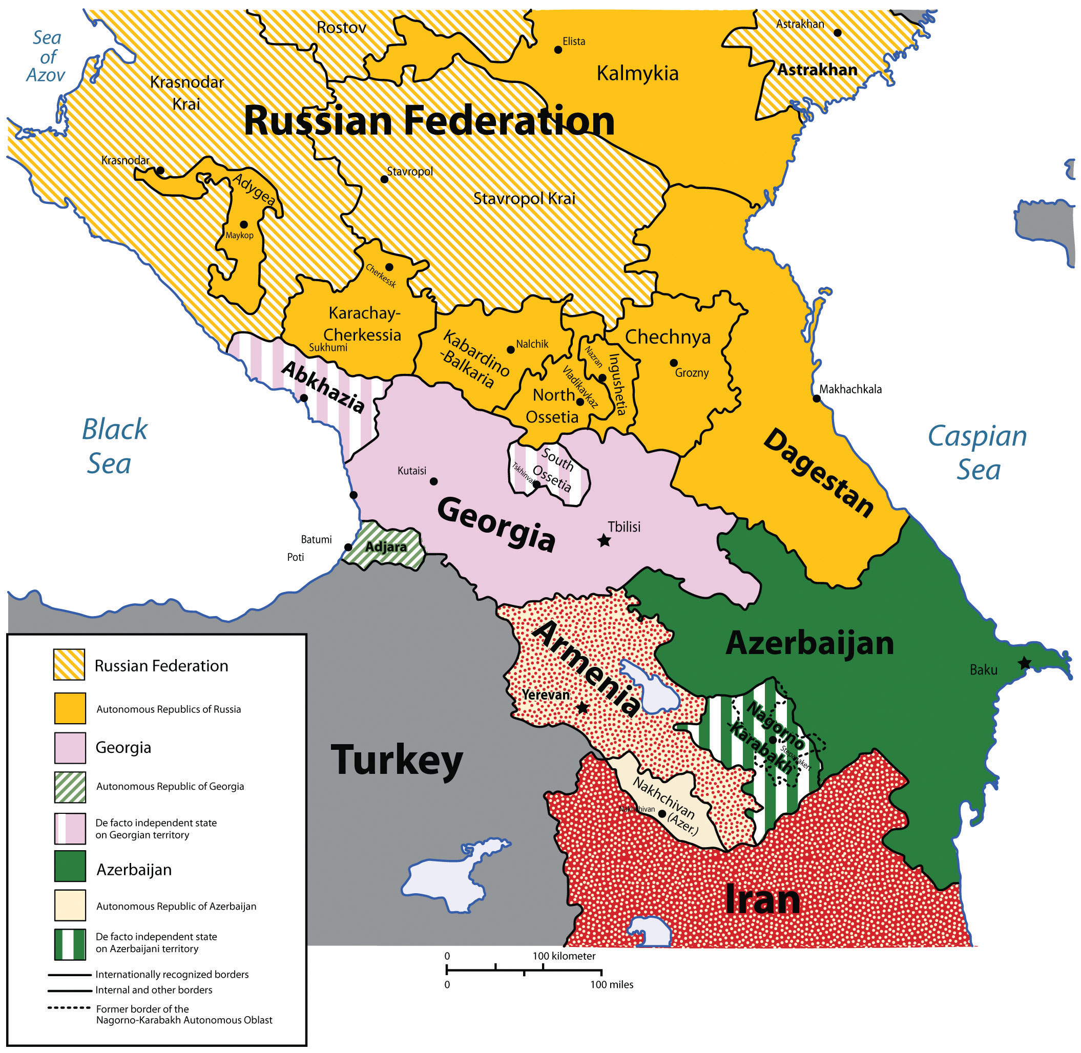
Political

The Caucasus is one of the most culturally complex and linguistically diverse parts of the world, often noted for its geopolitical intricacy and intractable conflicts. Despite the importance of the Caucasus, the region is often overlooked in the international media. When noticed, it is usually portrayed as a remote and violence-plagued place, a jumble of mountains situated at the periphery of some other region: the Russian extreme south, the Middle Eastern extreme north, or the European extreme southeast. Great Overview Article > 
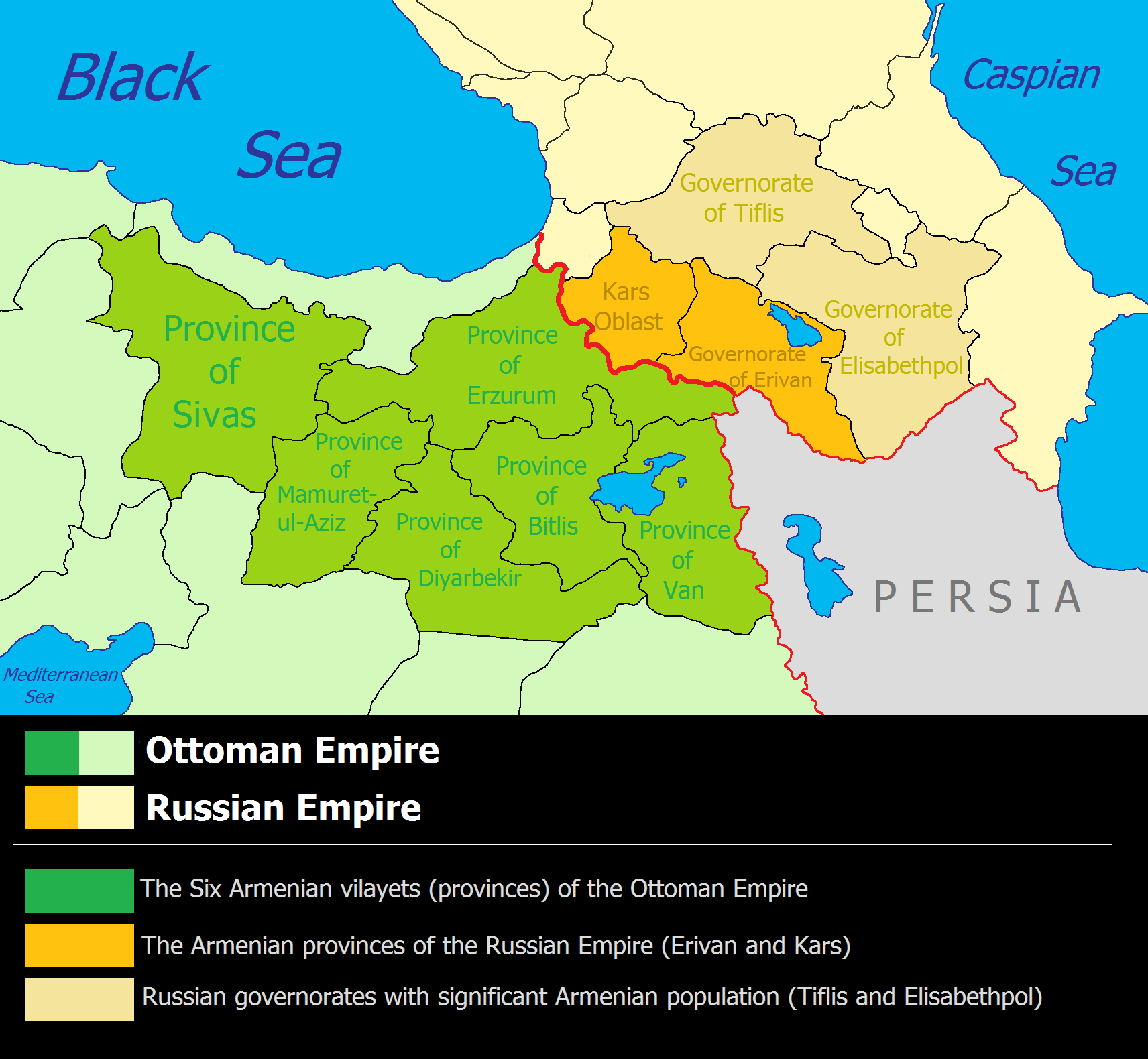
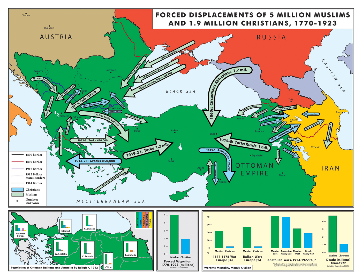
Ottoman, Persian and Russian Empires


Population and Migration

Population migration and displacement in the Southern Caucasus, 1988-200

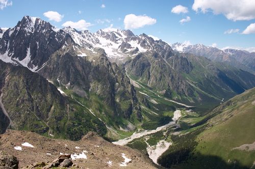
Elevation

The Caucasus Mountains formed largely as the result of a tectonic plate collision between the Arabian plate moving northwards with respect to the Eurasian plate and the entire region is regularly subjected to strong earthquakes. The Caucasus Mountains are known for the high amount of snowfall: snow cover in several regions may reach 5 metres (16 ft) and Europe's highest mountain--Mount Elbrus 5,642 m (18,510 ft)-- is located in the Caucasus Mountains.

Article >

Wikipedia >


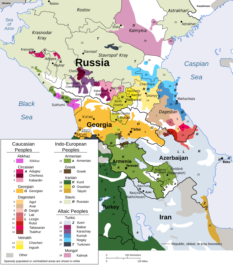
Ethnic Plurality

The region has many different languages and language families. There are more than 50 ethnic groups living in the region.

Article > 


Language Families

The Caucasus is one of the most linguistically and culturally diverse regions on Earth.

Article >


Religion


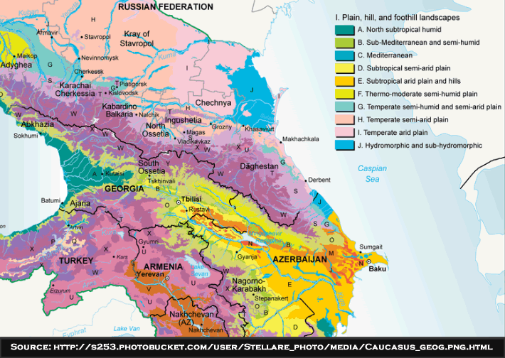
Climate

The Caucasus is an area of great ecological importance. The region is included in the list of 34 world biodiversity hotspots. It harbors some 6400 species of higher plants, 1600 of which are endemic to the region.
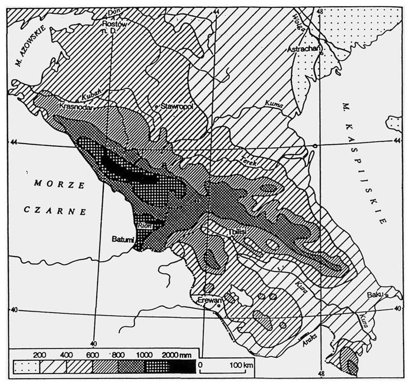
Rainfall


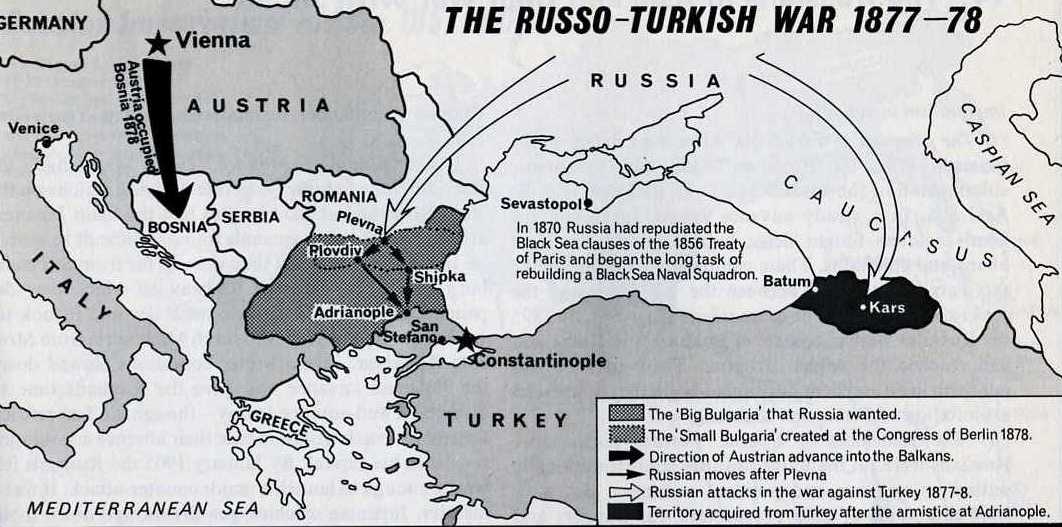
Wars

Instability in the North Caucasus has its roots in centuries of imperial conquest and local resistance. Cossacks began settling the region as agents of Russian expansion in the late eighteenth century, and the Russian Empire waged the nearly half-century Caucasian War from 1817 to 1864. A seemingly never-ending saga of turmoil, the region was a hotbed of dispute between the Ottoman, Persian and Russia Empires.

 Article >

(Extensive Map Library)

Lastly, Google “Caucasus At War” for much more in-depth coverage of this subject.

Part Two will be about the lesser known ethnic cleansings and subsequent diasporas in the Caucasus...

Tuesday, May 26, 2015

Mapping Historical New York City

Now this is cool!...
Manhattan Park Avenue 46th Street Looking North
(Before the high rises were built)
1922 - Astoria showing the Hell Gate Bridge.
1884
View of the sightseeing public walking the length of Brooklyn Bridge during its construction.

Article >

Mapping the New York That Once Was

Interactive map >

(navigation to a huge array of historical photos)

Saturday, March 7, 2015

Unveiling the Past - Ghost Embankments

As I have posted earlier on this blog (DIY - Railroad History Research), finding “ghost Embankments” on topo maps is a great way to locate abandoned railroad lines.

A trek to a set of stacked abandoned railroad tunnels last December (Abandoned Railroad Tunnels) was an exciting venture “in the field.” The curious nature of two levels of tunnels was made even more clear when viewed on a map or satellite view.

Selecting the Topo choice in Acme Mapper shows where the old railroad lines where by clearly indicating embankments. Acme Topo Map

Overview of Newtown Railroads >

Go To Article for further details (more maps, etc.)


Sunday, December 28, 2014

Historical Maps of Connecticut Railroads and Trolleys

A compilation of Connecticut historical railroad and trolley maps. Thumbnail navigation provides easy visual access to a variety of online maps and historical info.


Article >


Sunday, November 16, 2014

Visualizing Global Migration

Both Vintage and "Cutting Edge" Maps of Global Migration
 Global Migration circa 1858

Article >


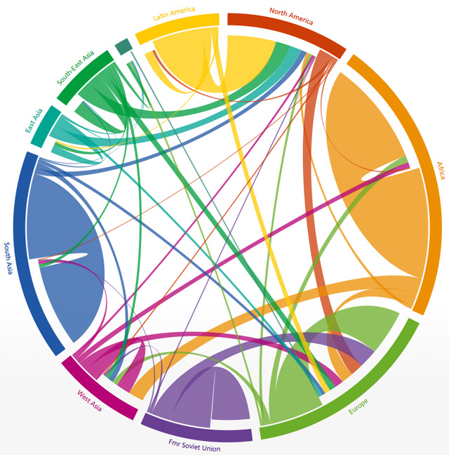
The Global Flow of People

Five-year periods, 1990 to 2010

Friday, October 17, 2014

Interactive Video Timeline


Intersting interactive timeline allows you to preview historic newsreels captured since 1896. A slider on the bottom on the the timeline allows you to browse by decade. There are some really informative and priceless historical clips - A great visual history lesson!

Interactive Timeline > 


Friday, August 22, 2014

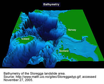
Massive Underwater Landslide

Storegga Slide

A 200-mile chunk of the continental shelf the size of Iceland collapsed in 8,200 BC creating a massive tsunami.It was so powerful it turned Britain from a European peninsula into an island.


Animated


BBC Video

Article >


Tuesday, December 31, 2013

Atlas of U.S. Historical Geography


Atlas of the Historical Geography of the United States


The Atlas of the Historical Geography of the United States was originally published in 1932 and was recently digitized and made available online by the Digital Scholarship Lab at The University of Richmond

There is an amazing array of historical info here. 

  • Railroad expansion
  • Native American History
  • Politics thru the years
  • Territorial Claims
  • U.S. Military History
  •  ... you name it!  

The Table of Contets is nicely organized and easily navigable
Atlas >


Monday, December 30, 2013

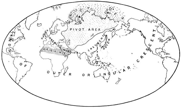
The never-ending quest for the perfect map


Pictured above: The Pivot Map
"Politics is driven to some extent by geographic issues..."
- English geographer and imperialist Halford Mackinder

From Ptolemy  to Google, interesting article on the evolution of maps.

Wednesday, March 27, 2013

Thursday, January 24, 2013

Graphic > Deconstructing a Ford plant

An historical saga all in one graphic...

What a great graphic! So much info yet it is tightly organized and easy to understand. The comparison to the Empire State Building is very simple yet powerful - the viewer immediately grasps just how huge this plant really is. The Worker Timeline red circles very simply displays at a glance the amount of workers involved at various times.

Article
http://cdn.theatlantic.com/static/coma/images/issues/200904/map-ford.jpg

Disassembly Line 
http://thesocietypages.org/graphicsociology/tag/atlantic-monthly/
(Click on Graphic to enlarge in a modal window)
All in all, a brilliant piece of work.