Monday, October 17, 2022

The Russian Empire

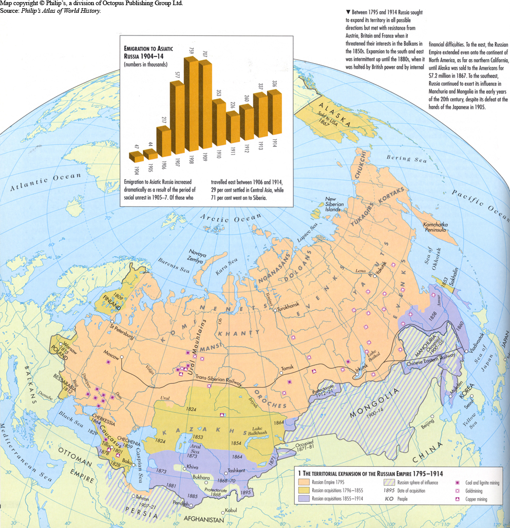
The Russian Empire spanned Eurasia from 1721 to 1917 and also held colonies in North America between 1799 and 1867. Covering an area of approximately 8,800,000 square miles, it remains the third-largest empire in history, surpassed only by the British Empire and the Mongol Empire.

At the beginning of the 19th century, the territory of the Russian Empire extended from the Arctic Ocean in the north to the Black Sea in the south, and from the Baltic Sea in the west to Alaska, Hawaii, and California in the east. By the end of the 19th century, it had expanded its control over most of Central Asia and parts of Northeast Asia.

Following Russia's role in defeating Napoleonic France, the Russian Empire played a leading political role in the next century, although its retention of serfdom precluded economic progress to any significant degree. As Western European economic growth accelerated during the Industrial Revolution, Russia began to lag ever farther behind, creating new weaknesses for the Empire seeking to play a role as a great power. 

Growth of the Russian Empire

Expansion of Russia, 1300–1796
Expansion of Russia, 1462-1796
Expansion of the Russian Empire, 1795-1914
Russian penetration of Central Asia
Russian expansion in Asia
(1533 - 1894)

Monday, August 8, 2022

Scribner's 1883 USA statistical atlas

Scribner's statistical atlas of the United States, showing by graphic methods their present condition and their political, social and industrial development. Amazing maps, infographics, etc. from 1880!

A random sampling...

Presidential Election History
Image 36


Irish
Image 79

Insane and Idiotic 
Image 91

Illiteracy
Image 111


Interactive Atlas >
Library of Congress Geography and Map Division


U.S. Indian tribes, reservations and settlements

Indian tribes, reservations and settlements in the United States 

1939 - Library of Congress Geography and Map Division


Friday, July 1, 2022

An Amazing Assortment of Railroad Maps

The David Rumsey Historical Map Collection has a great assortment of historical maps, including quite a few railroad maps. The interface to zoom in and pan is really well implemented and the maps listed below are wonderful visual references to the importance of railroading in the late 1800s and the turn of the century.

Erie Railroad - 1927

Interactive Map > 


Lackawanna Railroad.
The Road of Anthracite. Through Car Routes

Lovely Pamphlet >

Interactive Map > 


Santa Fe -  1904


Railways of Canada - 1886


Railroad map U.S. - 1890


Denver and Rio Grande Railroad System - 1883


Saturday, June 25, 2022

Map Quizzes

Geography Games - Seterra Geography  Quizzes

This is a great site - there are a large assortment of map quizzes to choose from. Some are easy, some are fairly difficult! Highly recommended...


Map Quizzes >


Tuesday, March 15, 2022

Early Human Migration

Fascinating data visualizations of our migratory ancestry as humans ...

How did our species become the last surviving hominin on the planet?

Max Planck Institute and the University of Michigan

Article >

27 million people linked in largest-ever family tree

Researchers at the University of Oxford’s Big Data Institute have created the largest-ever family tree, which links more than 27 million people — both living and long dead — across the world.

Article >

Monday, February 28, 2022

Point Nemo

Have you ever heard of Point Nemo?

At more than 1,000 miles from civilization, its considered the most remote location on Planet Earth... It lies between New Zealand and South America and is fittingly known as the spacecraft cemetery, as the United States, Russia, Japan, and Europe have used it to dump some 263 pieces of space debris since 1971.

Friday, February 25, 2022

Antique New York State Maps

  • From the David Rumsey Collection
  • Fully Interactive (pan, zoom, etc.)

Map Of The State Of New York With the Latest Improvements (1845)

Interactive Map >

Note the side panel illustrations of Mountains and Rivers

  • Ballston Lake = Long Lake 
  • Lake George Village = Caldwell

Engineers Map of The State Of New York (1864)

Showing State Division into "agricultural Groups"

Interactive Map >

  • Outline color by agricultural group. 
  • Shows canals, railroads in operation, in progress, and proposed.
  • Note clear views of the railroads

1879 - New York Wilderness And The Adirondacks

  • Great Detail
  • Even many hotels are listed!

New York State - 1895

Interactive Map >

Tuesday, February 15, 2022

Where angry waters roll (1936 US Flood Map)

Where angry waters roll (1936 US Flood Map)

Fascinating data visualization of flood prone areas across the United States from the David Rumsey Collection 


Interactive Map >
(zoom and pan)


Friday, February 4, 2022

The Tallest Lifeforms (Video)

These are screenshots from a wonderful video: "The Tallest Lifeforms Of All Time". Great use of analytic visual comparisons...

Watch Video >

Thursday, February 3, 2022

How Earth Would Look If All The Ice Melted

There's a very powerful video on YouTube illustrating
"How Earth Would Look If All The Ice Melted"

YouTube Video >

Highly recommended! - Below are a few screenshots...

India and Bangladesh
The west coast of Africa
China
U.S.A. Southeast
Australia


Sunday, January 30, 2022

Wednesday, January 5, 2022

What's the Golden Rule and the Green Rule?

 What's the Golden Rule?

The Golden Rule is the principle of treating others as one wants to be treated. It is a maxim that is found in most religions and cultures

The Golden Rule is the principle of treating others as one wants to be treated. It is a maxim that is found in most religions and cultures

The idea dates at least to the early Confucian times (551–479 BCE), appearing prominently in Buddhism, Christianity, Hinduism, Islam, Judaism, Taoism, Zoroastrianism, and "the rest of the world's major religions".


What's the Green Rule?

The Green Rule is derived from the classic Golden Rule found in major faith traditions, paraphrasing it by saying: "Do unto the Earth as you would have it do unto you."

Selected from many of the world’s great religious texts and spiritual teachings, the Green Rules were chosen to demonstrate that each religion and spiritual philosophy has a long-standing tradition of ecological stewardship...


Religions

Animated map showing how religion spread around the world
(YouTube  / Business Insider)

Mapping Deforestation

Mapped: 30 Years of Deforestation and Forest Growth, by Country

Today, forests make up around 31% of the Earth’s total land area, spanning 15.68 million square miles (40.6 million km²). Over the past three decades, the world lost a bit more than 4% (685,300 square miles) of its forests, which equates to an area about half the size of India.

Europe and Asia were the only two regions which had significant overall forest growth during this time period, while Oceania saw no significant change and North and Central America saw a slight reduction.

Africa along with South America and the Caribbean were the regions with the greatest amount of deforestation, both losing more than 15% of their forests over the past 30 years. 

Article >