Thursday, May 30, 2013

Internet Trends (Quick Chart Summary)

America's Media Attention in One Graph

Facebook in Decline

Other Charted Trends...
  • Today the Internet Is Photos
  • Apple and Samsung Ate the World and IoS and Android are burying WinTel

The 11 Most Fascinating Charts of Internet Trends

Saturday, May 25, 2013

United States - Visual Quick Study

U.S. Climate Zones


U.S. Forests


U.S. Mountain Ranges


(both kinda lame?)

U.S. Watershed


Regions


U.S. Rainfall


Average 1981 - 2010

Major U.S. Rivers


U.S. Population Density


In 3D

Tuesday, May 14, 2013

The Mother Lode of High-rez Free Topo Maps

West Point at 200% 
(you can zoom in much higher!)

Download Free Topo Maps
 (Hi-rez Vector Topo Maps with on/off layering)
(see instructions and type in your city)


Thursday, May 9, 2013

The World's Leading Science Cities


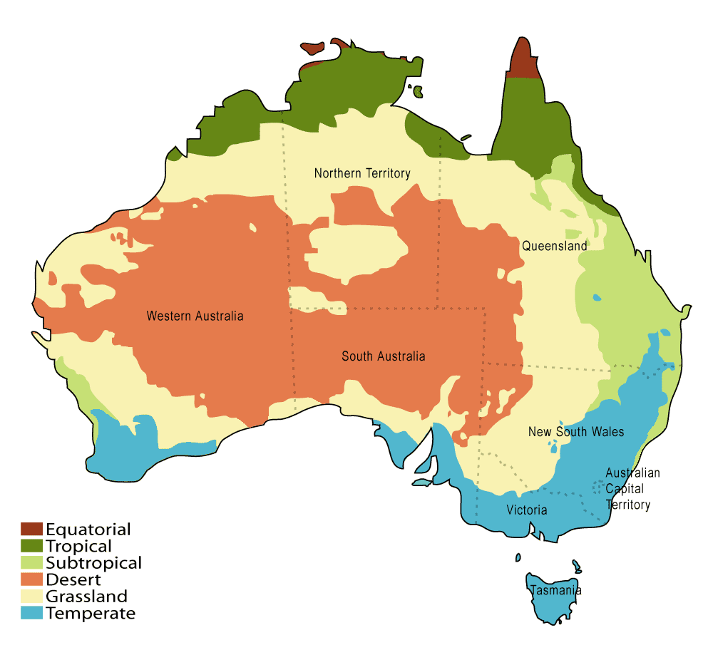
Science Cities - Producers vs. Consumers

Cities that produce knowledge are red; those that consume it are blue

Within the U.S., there has been a shift in scientific production from the "major urban areas" of the East and West Coasts to a broader geographic distribution which includes centers in the Midwest and South

Despite America's overall decline, major cities and urban centers on the east and west coast remain the leading centers of physics over this period. The U.S. had 17 of the top 20 cities in 1990 and 14 in 2009

NOTE:
While Chinese cities have risen as consumers of scientific knowledge (alongside their economic growth), it remains to be seen if they can become leading  producers of it. 

Wednesday, May 8, 2013

The Housing + Transportation Affordability Index

This interactive map is amazing!

http://htaindex.cnt.org/map/
(A good sequel to yesterday's post...)

The Housing + Transportation Affordability Index is an innovative tool that measures the true affordability of housing based on its location.  Users can view housing and transportation data as maps, charts, and statistics for nearly 900 metropolitan and micropolitan areas—covering 89 percent of the U.S. population. 

The interactive mapping tool was designed to enable individuals, planners, and policymakers to more fully grasp and act on the relationship between development patterns, transportation behavior, and household transportation costs. 

Tuesday, May 7, 2013

U.S. Housing Cost Burden

Where Working Households Are Struggling the Most to Pay Their Rent


Yikes -- Miami beats New York! 

Wednesday, May 1, 2013

U.S. Map, Brood II, Where the Cicadas Are Now Emerging, Cicadas, Cicadas Map, Cicadas Emerging

Watch out for the notorious Brood II!

The insects are harmless but extremely loud and a pain to walk or bike through, seeing as how they can number in the hundreds of thousands in just one square acre.