Saturday, May 29, 2021

Native American Names - Glastonbury CT Area

No matter where you may venture to in the U.S. -- it seems you can find tribute/evidence of native American origins if you know where to look...

  • Wangunk (“where the river bends”)
  • Nayaug  ("noisy waters")
  • Naubuc (flat plains to the north”)
  • Neipsic ("water near the hill") or Nipsic

The Native Americans of the present-day Glastonbury/Portland area were members of Algonkian-speaking tribes. They lived in clans of approximately 100 individuals and each group was ruled by a sachem or chief. Clans took names from features of the land where they were centered. Naubucs lived in the plains to the east, the flat area at the north end of town. Nayaugs lived a bit further south near the Noisy Water at the mouth of Roaring Brook (note: they were also known as the Red Hill Indians). Wangonks lived at the bend in the river behind today’s Town Hall, where the Connecticut River turned in the 1600s. The Neipsic springs first attracted Native Americans who came for the water's mystical healing powers. Today, the water still bubbles up from the hillsides in Glastonbury's J.B. Williams Park found on Neipsic Road.

The tribes were peaceful and farmed the land. In the summer, clans lived along the river in longhouses. In winter, they moved to the hills and lived in south- or west-facing caves. 


You can find the following names on the map above as well
  • Knogscut ("place of wild goose') - Knogscut Mountain >
  • Minnechaug ("berrylnd") - Even the golf course, when heading to Manchester, has a a Native American name!

Other Places Nearby

  • Meshomasic (“the great snake” or “land of many snakes”) - State Park >
  • Shenipsit (“at the great pool”) refers to the Shenipsit Lake, which the Shenipsit trail passes by

Wednesday, May 12, 2021

The Connecticut River

Did you know?

  • The Connecticut River is named after the Pequot word “quinetucket,” meaning long tidal river. The European corruption of that begat “Connecticut.”
  • The Connecticut River is tidal and navigable as far inland as Hartford, CT sixty miles from the Sound. Large oil barges with shallow drafts regularly make the trip upstream to Hartford.
  • 410 miles long, the Connecticut River is New England’s longest river running through four states: New Hampshire, Vermont, Massachusetts and Connecticut.
  • 70% of all the fresh water entering Long Island Sound comes from the Connecticut River.


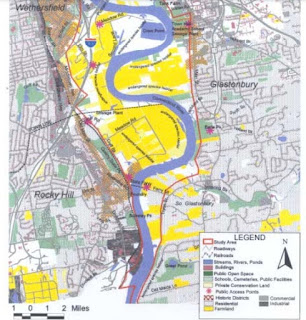
The Meandering River through the Glastonbury "Reach"

The Floodplain
The large area south of Hartford, Connecticut along the Connecticut River is known as the Great Meadows. It's a large inland wetland and a significant regional resource. The Connecticut River meanders through the Meadows and has shifted considerably over time. The fertile floodplain soils of the Meadows are an important agricultural resource and farmland and farms are abundant throughout the area.
Yellow areas are farmland
Source

Glastonbury Reach
The floodplain area is known geographically as the "Glastonbury Reach". Over time, this stretch of the river has shifted its course. One dramatic example occurred in occurred in 1692 when a flood altered the course of the river in Wethersfield. The flood shifted the course of the rover to the east and swept away all but one warehouse. 

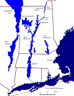
Ancient Glacial Lake Hitchcock

Lake Hitchcock was a glacial lake that formed approximately 15,000 years ago in the late Pleistocene epoch. After the Laurentide Ice Sheet retreated, glacial ice melt accumulated at the terminal moraine and blocked up the Connecticut River, creating the long, narrow lake. It stretched from present-day Rocky Hill, Connecticut to St. Johnsbury, Vermont: about 200 miles! 

Part of the ancient sediment dam that contained Lake Hitchcock is still visible today as a sand pit at Dividend Pond Trails and Archaeological District in Rocky Hill. Sands dunes built up along the shore of the lake can also be seen today at Matianuck Sand Dunes Natural Area Preserve in Windsor.

Source

Part of the ancient sediment dam that contained Lake Hitchcock is still visible today as a sand pit at Dividend Pond Trails and Archaeological District in Rocky Hill:

Huh  -- What's the deal re this square-shaped lake?

Crow Point Cove's shape is man-made. The cove was excavated for highway construction of the interstate 91 embankment nearby.