Did you know?
- The Connecticut River is named after the Pequot word “quinetucket,” meaning long tidal river. The European corruption of that begat “Connecticut.”
- The Connecticut River is tidal and navigable as far inland as Hartford, CT sixty miles from the Sound. Large oil barges with shallow drafts regularly make the trip upstream to Hartford.
- 410 miles long, the Connecticut River is New England’s longest river running through four states: New Hampshire, Vermont, Massachusetts and Connecticut.
- 70% of all the fresh water entering Long Island Sound comes from the Connecticut River.
The Meandering River through the Glastonbury "Reach"
The Floodplain
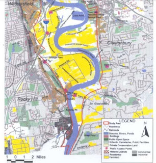
The large area south of Hartford, Connecticut along the Connecticut River is known as the Great Meadows. It's a large inland wetland and a significant regional resource. The Connecticut River meanders through the Meadows and has shifted considerably over time. The fertile floodplain soils of the Meadows are an important agricultural resource and farmland and farms are abundant throughout the area.
 |
| Yellow areas are farmland Source |
Glastonbury Reach
The floodplain area is known geographically as the "Glastonbury Reach". Over time, this stretch of the river has shifted its course. One dramatic example occurred in occurred in 1692 when a flood altered the course of the river in Wethersfield. The flood shifted the course of the rover to the east and swept away all but one warehouse.
Ancient Glacial Lake Hitchcock
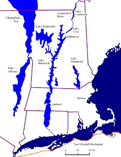
Lake Hitchcock was a glacial lake that formed approximately 15,000 years ago in the late Pleistocene epoch. After the Laurentide Ice Sheet retreated, glacial ice melt accumulated at the terminal moraine and blocked up the Connecticut River, creating the long, narrow lake. It stretched from present-day Rocky Hill, Connecticut to St. Johnsbury, Vermont: about 200 miles!
Part of the ancient sediment dam that contained Lake Hitchcock is still visible today as a sand pit at Dividend Pond Trails and Archaeological District in Rocky Hill. Sands dunes built up along the shore of the lake can also be seen today at Matianuck Sand Dunes Natural Area Preserve in Windsor.
 |
| Source |
Huh -- What's the deal re this square-shaped lake?
Crow Point Cove's shape is man-made. The cove was excavated for highway construction of the interstate 91 embankment nearby.
Further Info / Source Info
- CT River Watershed Facts (Connecticut River Conservancy)
- The Great Meadows of the Connecticut River (PDF)
- Geomorphology of the Connecticut River - Glastonbury Reach
- Glacial Lake Hitchcock (Wikipedia)
- Getting to Know Glacial Lake Hitchcock (CT Science Center)
- Glacial Lake Hitchcock Sediment Dam
- Sedimentation in a proglacial lake: Glacial Lake Hitchcock


No comments:
Post a Comment