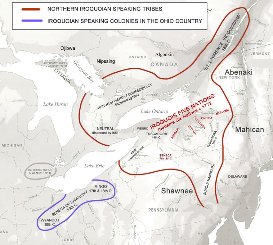
Reports on three important villages of the Mohawk tribe, the easternmost of the five historically known tribes that comprised the famed League of the Iroquois. The Mohawk tribe occupied the area between the modern village of Little Falls and the city of Amsterdam. This tribal territory was approximately 40 miles wide from east to west and 20 miles wide from north to south.
Why Were These Sites Chosen By The Mohawk?
The Garoga, Klock, and Smith-Pagerie sites are all located in Ephratah Township, Fulton County, New York. They are situated on high, easily defended ridges in the drainage of Caroga Creek, a major tributary of the Mohawk River.
The processes of erosion, and glacial infilling formed the ancient down-cutting streambed of Caroga Creek (similar to a number of other stream beds that dissect the valley). These drainage systems carried massive amounts of water down the valley floor. Over tens of thousands of years, these streams deeply incised the soft underlying sedimentary bedrock creating narrow and deep gorges or “hollows”
The highly developed series of meanders that characterized these tributaries created numerous isolated oxbows and ridges protected on three sides by stream-cut cliffs and embankments. Thousands of years after retreat of the Wisconsinan ice, which took place around 12,000 years ago, these elevated and isolated locations were sought after by the Mohawk Iroquois for the natural defenses they provided.
Maps
Techniques for Uncovering and Understanding Native American Vestiges
Post Molds - The most common technique for investigating the archaeological remains of longhouses is by exposing post-mold patterns either by mechanical stripping or hand excavation. Post molds are the filled voids in the ground created by past structural elements long since removed, burned, or rotted away. Usually circular on the exposed surface and tapering or conical in cross-section, they are often only recognizable through careful identification of differences in soil color and texture defining the outline of the mold.
Magnetometry, a relatively new technique used by the Mohawk Valley Project, has proven to be useful for site investigations in some instances. Under certain conditions a magnetometer can locate fired clay features, such as hearths, because they create a subtle distortion in the magnetic field. Comprehensive survey of a site taking magnetometer readings at regular intervals can be used to produce a shaded contour plot depicting magnetic anomalies. These anomalies can then be tested in the field using soil auguring to verify the presence or absence of hearths. Because longhouses were typified by fire hearths located along the central aisle, identification of a linear pattern of hearths often indicates the presence of a longhouse.
- Source -
NEW YORK STATE MUSEUM BULLETIN 503
by Robert E. Funk and Robert D. Kuhn
2003