Wednesday, November 30, 2016

Amazing Amazonia (Part 1)

Amazonia or the Amazon Jungle, is a moist broadleaf forest that covers most of the Amazon basin of South America. This basin encompasses 2,700,000 square miles, 2,100,000 square miles of which are covered by the rainforest.

This region includes territory belonging to nine nations. The majority of the forest is contained within Brazil, with 60% of the rainforest, followed by Peru with 13%, Colombia with 10%, and with minor amounts in six other nations.

The Amazon represents over half of the planet's remaining rainforests, and comprises the largest and most biodiverse tract of tropical rainforest in the world, with an estimated 390 billion individual trees divided into 16,000 species.
Amazon size comparison
Amazon Watershed

Terrain / Mountains

Climate

Sahara Desert dust 

More than 56% of the dust fertilizing the Amazon rainforest comes from the Sahara desert. The dust contains phosphorus, important for plant growth. The yearly Sahara dust replaces the equivalent amount of phosphorus washed away yearly in Amazon soil from rains and floods. Up to 50 million tons of Sahara dust per year are blown across the Atlantic Ocean.
Vegetation
Land Use
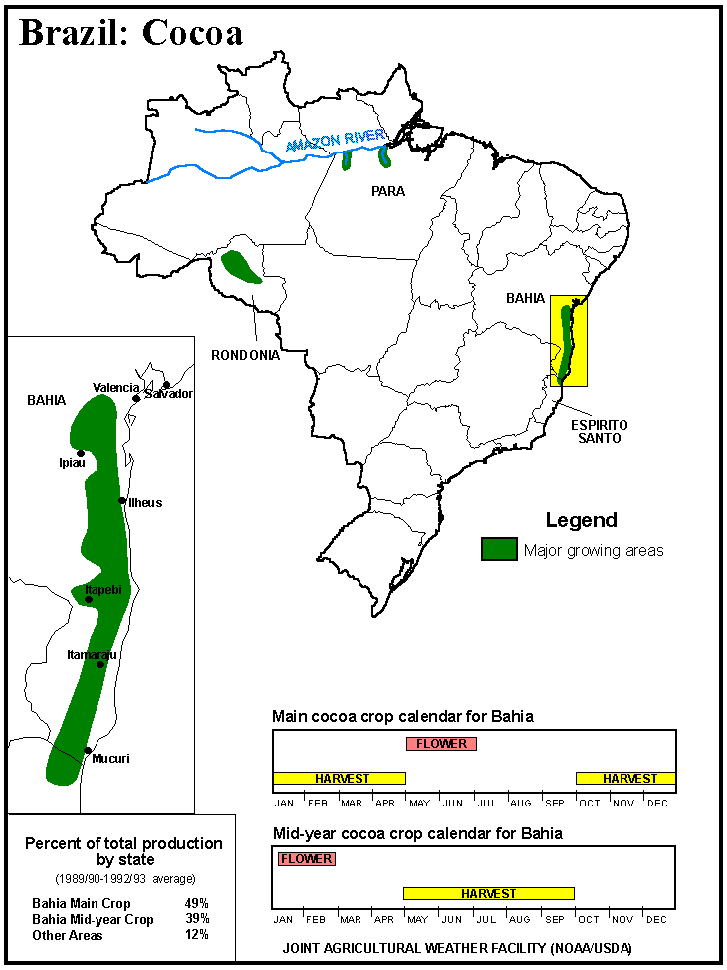
Where cocoa is cultivated
Population Density
Rocks - Geology

Deforestation of the Amazon rainforest

The cattle business has been responsible for about 80% of all deforestation in the region, or about 14% of the world's total annual deforestation, making it the world's largest single driver of deforestation.

The annual rate of deforestation in the Amazon region dramatically increased from 1991 to 2003. In the nine years from 1991 to 2000, the total area of Amazon rainforest cleared since 1970 was comparable to the land area of Spain, Madagascar or Manitoba. Most of this lost forest was replaced by pasture for cattle.
Deforestation

Indigenous People

Part Two will be focused on the Indigenous People and their surprisingly sophisticated culture (their prior cities recently discovered and their successful large scale agriculture techniques)...
Indigenous Territories

Sunday, November 20, 2016

The Lost City of Z

I just happened to pick up this book in the local library: “The Lost City of Z: A Tale of Deadly Obsession”. Its about the English colonel Percy Harrison Fawcett, who dedicated years to explore and to map much of the uncharted Amazon is the far reaches of Bolivia and Brazil. Often considered one of the most extraordinary explorers of the 20th century, his adventures mirrored the modern day Indiana Jones and inspired Sir Arthur Conan Doyle’s bestseller “The Lost World” (1912). His eight and final expedition and his sensational disappearance made headlines around the world.
His trips were sponsored by the British Royal Geographical Society and his meticulous note keeping were instrumental in mapping much of the unknown parts of Western Amazonia.

Who was Percy Fawcett?

Percy Fawcett began his career as a map maker and explorer, cataloging the disputed border between Bolivia and Brazil. He made a name for himself by being unafraid to venture away from the rivers and move inland. He adopted a policy of peace with the native Indians and gradually grew to respect them immensely.
Percy Fawcett
Map of Percy Fawcett’s Expeditions: source

The book focuses on Fawcett’s expeditions in the lower Xingu, a southern tributary of the Amazon. Here Fawcett believed he would discover a great lost city which he named “Z”.

El Dorado - the mythical city of gold

For centuries Europeans believed the world’s largest jungle concealed the glittering kingdom of El Dorado. Thousands had died looking for it. In pursuit of the legend, Spanish conquistadors and numerous others for years searched Colombia, Venezuela, and parts of Guyana and northern Brazil for the city and its supposed fabulous king. In the course of these explorations, much of northern South America, including the Amazon River, was mapped. By the beginning of the 19th century most people dismissed the existence of the city as a myth.

While earlier expeditions across much of South and Central America were unsuccessful in locating this city of gold, Percy Fawcett was convinced he could. Getting an assignment from the Royal Geographical Society to map the remote still unknown regions of Amazonia in Bolivia and Brazil was a perfect opportunity to fulfill his dreams. In 1925, Fawcett, along with his son Jack and Jack's best friend Raleigh, disappeared into the jungle after declaring that they knew where the Lost City of Z was located.

In the next seven decades, scores of explorers had tried and failed to retrace Fawcett’s path. Some nearly died of starvation, while others retreated in the face of tribes that attacked with poisoned arrows. Then there were those adventurers who had gone to find Fawcett and, instead, disappeared along with him, swallowed by the same forests in the Mato Grosso region which travellers had long ago christened the “green hell.”

Fawcett's Expeditions - 1906 to 1914


See the Official Royal Geographical Society Map by Percy Fawcett (Copyrighted)

Click on Thumbnail Image to View 


 Map of The Final Expedition


Friday, October 21, 2016

Music Mechanics Series - Tracker Organ

The organ is a fascinating mechanical contraption. Along with the clock, it was considered one of the most complex human-made mechanical creations before the Industrial Revolution. The instrument traces its history as far back as at least the 3rd Century B.C. and uses wind moving through pipes to produce sounds.

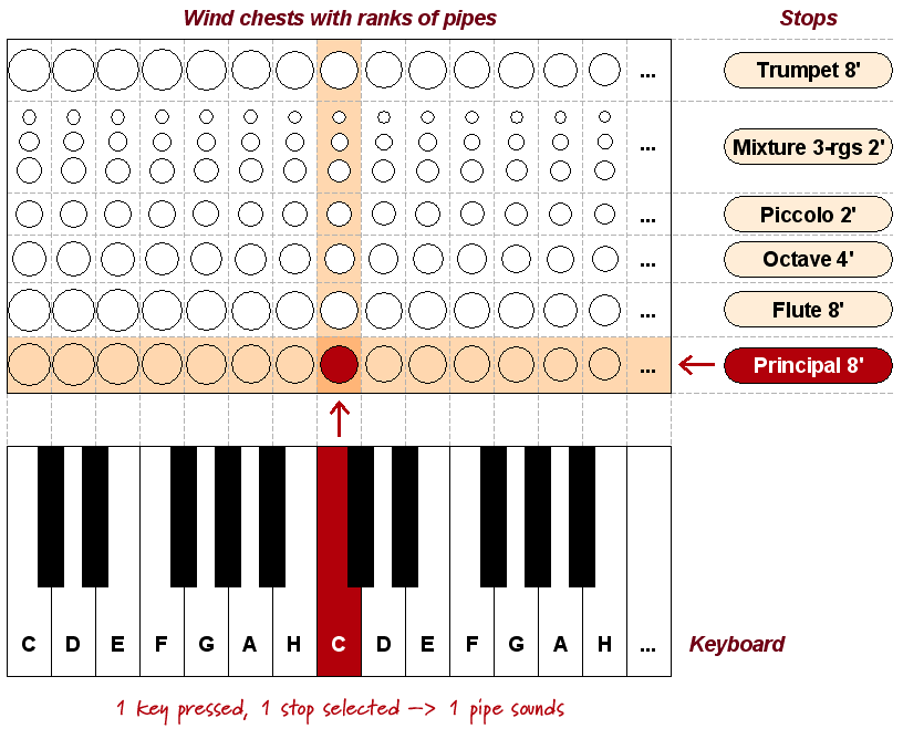
Since the 16th century, pipe organs have used various materials for pipes, which can vary widely in timbre and volume. The pipes are divided into ranks and controlled by the use of hand stops and combination pistons.

The Mechanics
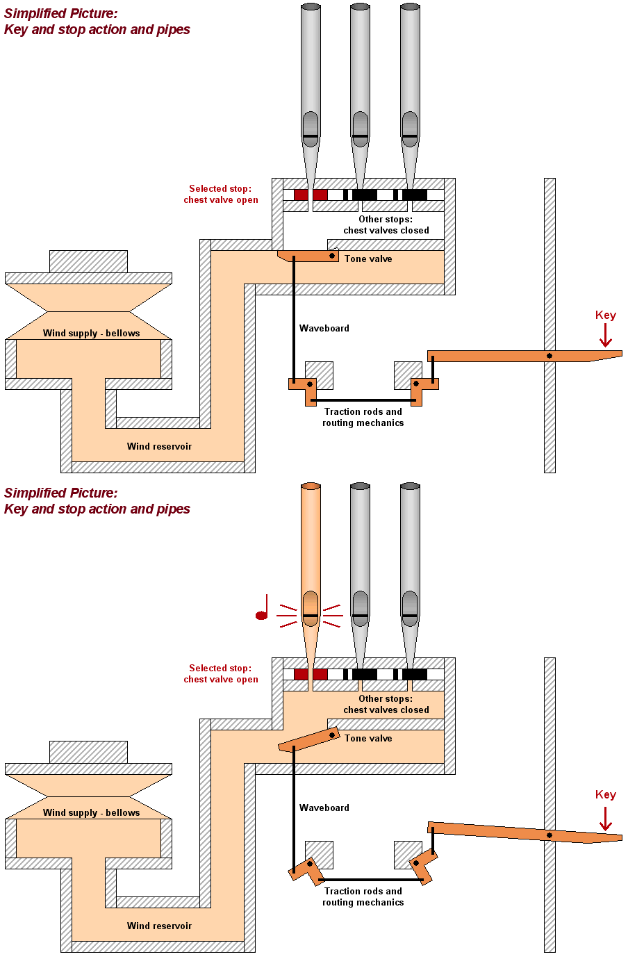
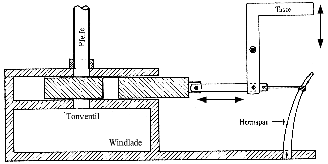
Below are an assortment of diagrams (one is even animated), all created to help illustrate the mechanics of how an organ works...


Tracker Organ

A Tracker organ uses tracker action -  a term to indicate a mechanical linkage between keys or pedals pressed by the organist and the valve that allows air to flow into pipe(s) of the corresponding note. This is in contrast to (1) direct electric action which connect the key to the valve through an electrical link or (2) electro-pneumatic action  which connect the key to an electrically assisted pneumatic system respectively, or (3) tubular-pneumatic action which utilizes a change of pressure within lead tubing which connects the key to the valve pneumatic.


Did You Know?

  • The loudest organ stop in the world is the Grand Ophicleide located in the Right Pedal division of the Boardwalk Hall Auditorium Organ (see link below). It is described as having "a pure trumpet note of ear-splitting volume, more than six times the volume of the loudest locomotive whistle." The Grand Ophicleide produces up to 130 decibels at a distance of 1 meter. A former organ curator warned the stagehands when the Grand Ophicleide was going to be used, because of the volume.
  • The air needed for the pipes to speak (usually called the "wind" by organ builders) used to be produced by people treading on or pumping up down on a lever to force wind into huge bellows on a side chamber of the organ. Today a blower worked by a huge electric motor has taken over this job, but the principle remains the same. Today a blower worked by a huge electric motor has taken over this job, but the principle remains the same.


Saturday, September 17, 2016

Cameron's Line

Did you know that New England was not always part of the North American continent? Slices of land known as terranes collided with North America ages ago. In geological terms, a terranes is a fault-bounded area or surface over which a particular rock or group of rocks is prevalent. As these collisions occurred, the terranes were squeezed, crumpled, deformed and intensely metamorphosed. This has made for some rather complex geology in the New England area.

A proto-continent ripped open during the Late Proterozoic era 700 million years ago, giving birth to an ocean named Iapetus. Then Iapetus's edges came together again essentially squeezing the sea out of existence.

Huge tectonic plates drifted and collided in a series of stages, eventually merging into the land mass of Northeastern U.S. as we know it today. The Roxbury Land Trust has an excellent illustrated guide (PDF) about the geological history of New England replete with details on the tectonic plates movements:
Source: Roxbury Land Trust (Geology)
The final merging and naming of all these terranes is a complicated saga, more thoroughly explained and illustrated on this site: “Exotic Terranes: the making of New England


Cameron’s Line in west Connecticut is a major thrust fault that separates (1) rocks that were originally part of the ancient Iapetus Ocean (deep ocean metasedimentary rocks) from (2) metamorphic rocks derived from the previous continental shelf and slope deposits to the west.
This line marks an abrupt change in the earth’s crust that resulted from a collision between North America and a European-African land mass 400 million years ago.
Source:
Weir Farm Geologic Resources Inventory Report

Monday, September 5, 2016

Visual Quick Study - Fracking in New York State

Much of western New York sits atop the natural gas-rich Marcellus shale, the same formation that has made neighboring Pennsylvania one of the country’s largest natural gas producers because of high-volume hydraulic fracturing operations. The Marcellus shale, stretching from Tennessee to New York, is estimated to contain about 84 trillion cubic feet of recoverable shale gas, up to 9 trillion of which is in the Empire State.

Did You Know?
December 22nd, 2014 - New York State became the first energy-rich state to ban the method of high-volume hydraulic fracturing, or fracking, used to extract natural gas found in underground shale formations. The ban came at about the same time that the Canadian provinces of Quebec and New Brunswick officials said they’d prevent shale gas development, too.

New York State Fracking Maps

Shale Gas Deposits in the Northeast


Fracking Map

Each dot on the map below represents one natural gas well. Most existing wells were drilled using conventional drilling methods. 


Fraccidents 


Friday, July 8, 2016

Music Mechanics Series - Mellotron

Mellotron 

The Mellotron was originally developed and built in Birmingham, England, in 1963. The original models were designed to be used in the home, and contained a variety of sounds, including automatic accompaniments! Adopted by the Moody Blues, Genesis and King Crimson, it became a notable instrument in progressive rock. Production of the Mellotron ceased in 1986.
A diagram illustrating the internal operations of a Mellotron

How it Worked

Pressing a key (1), caused two screws (2) to connect a pressure pad (3) with the tape head (5), and the pinch wheel (4) with the continuously rotating capstan (6). Tape was pulled by the capstan at a gradual speed controlled by a tension spring (8–10) and stored temporarily in a storage bin (7) until the key was released.

Interesting Facts:

  • Noted cellist Reginald Kirby refused to downtune his cello to cover the lower range of the Mellotron, and so the bottom notes are actually performed on a double bass.
  • Pressing a key harder allows the head to come into contact under greater pressure, so to an extent,  the Mellotron responds to aftertouch.
  • Among the early Mellotron owners were Princess Margaret, Peter Sellers, King Hussein of Jordan and Scientology founder L. Ron Hubbard!
  • The Skellotron (2005) was a Mellotron in a transparent glass case. Only one was made!

Article >