Sunday, November 24, 2019

Hidden Crater in the Catskills


Did you know about the "crater" in the Catskills?

The circular pattern made by the two creeks surrounding Panther Mountain suggest that it might have a different origin from other Catskill peaks. In the early 1970s, a geologist of the New York State Geological Survey at the New York State Museum in Albany wondered if the stream pattern indicated an impact crater buried beneath the surface.

The impact is estimated to have occurred 375 million years ago, during the Devonian period, when much of what is now the Catskills was either river delta or a shallow sea. The crater lies 2,640 feet below the surface, is 6 miles wide, and lies directly under the mountain. The meteorite that struck is believed to have been roughly one-half mile  wide, striking with a force equivalent to 11 trillion tons of TNT. -Wikipedia

Is the U.S. Better Off As A Bunch Of Separate Countries?

Food For Thought


  • Should the U.S.A. have a "velvet divorce,” (a reference to the 1993.peaceful dissolution of Czechoslovakia — now the Czech Republic and the Slovak Republic)
  • Has the U.S. has run its course and need breaking up?

Article >


Saturday, November 23, 2019

Mapping America's Loneliest Roads

Fascinating Study

A study which crunched 2015 annual average traffic data from the Highway Performance Monitoring System to find the least traveled roads in each state, and in all of America is now online as interactive map.


Interactive Map > 

The Soviet Military Secretly Mapped the Entire World

Interesting article!

In the early 2000s, a shop in Riga, Latvia’s capital held bundles of Cold War-era maps of British cities, created by the Soviet military

The Russian maps were supposed to be destroyed after the fall of the Soviet Union, but some officers, seeing an opportunity for profit, sold them. They have never been officially declassified. “Russians won’t talk about them, the people who created them will hold their secrets to the grave.”
Central Park, NYC

Article >

Thursday, September 12, 2019

How Human Activity Is Changing Animal Migration Patterns

Humans have long tracked the movements of animals by following their paw prints or staking out their natural habitats. That kind of observation still has its value today, but now biologists also benefit from a slew of satellite, radio, and GPS technologies that can track the digital footprints of, say, a herd of elephants or a flock of storks as they move across the globe. And at a time when both climate change and urban development are changing—and disrupting—the migration routes, there’s a new urgency in these kinds of research.

In southern California, mountain lions are in decline in part because of the expansive freeways that crisscross the state. When researchers tagged a sample of lions in Santa Ana with GPS devices, they found their natural habitats divided by as many as eight lanes of traffic, as well as houses, golf courses, and other private developments.


Despite proposals to build animal crossings after the fact, over- and underpasses have proven ineffective; they’re rarely used by the big cats. The risks go farther than just ending up as roadkill. The roads themselves become cages for mountain lion populations, isolating various groups and resulting in higher rates of inbreeding. This threatens their growth and survival as a whole.

Full article at Map Lab:

Its a fascinating read...

Friday, August 9, 2019

Native American History - New York State

Being equally fascinated with historical maps AND Native American history in upstate New York where I grew up - this post is a result of online research. There is a wealth of materials out there if you look :-)

Click on any Map for an enlargement and better yet, go to the link provided to see the the full version where you can zoom in and pan


-Part One-

New York State Library - Native American Materials
The New York State Library holds a wealth of first hand descriptions of the Native American experience in New York. These resources span four centuries, beginning with the Dutch colony of New Netherland and continuing to the close of the American frontier in western New York and beyond. Original manuscripts and maps serve as lenses through which cultural and historical interpretations can be made.

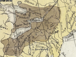
The Five Nations - 1747
A map of the country of the Five Nations belonging to the Province of New York, and of the lakes near which the nations of far Indians live, with part of Canada.
Created By: Bradford, William, 1663-1752
http://purl.nysed.gov/nysl/51719615

Six Nations and New York Province - 1771
Copied from the original map drawn by Guy Johnson in 1771, this map was printed in The Documentary History of the New York by E. B. O'Callaghan, volume 4, page 661.
Created: 1851
Guy Johnson came to American in 1756 and was the Irish-born nephew, son-in-law and protégé of Sir William Johnson. He became a deputy to Sir William Johnson in his uncle's position as British Superintendent of Indian Affairs and succeeded him when William died in 1774.

Iroquois Cantons Map - 1747
Map indicating "sites of Indian Village and Jesuit missions, in the 17th and 18th centuries, in relation to modern towns.
Created By: Beauchamp, William Martin, 1830-1925
http://purl.nysed.gov/nysl/44687294

Indian Trails in New York State - 1755
Map showing trails, portages and settlements from Albany to Niagara during Sir William Johnson's tenure as "Sole Superintendent of the Affairs of the Six United Nations, their Allies and Dependents" which he held from 1755 until his death in 1774.
Created by: Mitchell, Louis (based on the papers of Sir William Johnson, outline of trails furnished by W.M. Beauchamp)
http://purl.nysed.gov/nysl/44714090


-Part Two-

Historical Maps from the David Rumsey Historical Map Collection...

Indian Reservations in the Northeast (1840)
Published in 1932 by the Carnegie Institution of Washington, American Geographical Society of New York
David Rumsey Historical Map Collection
Indian Territory - Published 1836
Map of the Indian Tribes of North America about 1600 A.D. along the Atlantic and about 1800 A.D. westwardly. 
David Rumsey Historical Map Collection
Patents NY State showing Indian Reservations - 1895
David Rumsey Historical Map Collection
1763 - Map of Colonial Possessions (published in French)
"Possessions Angloises & Francoises du Continent de l'Amerique Septentrionale"
David Rumsey Historical Map Collection

-Part Three-

Plundered in Search of Indian Artifacts
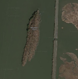
For more than 3,000 years, this alluring isle of stone in the Hudson River north of present-day Kingston has beckoned strangers.  Native Americans took shelter in a west-facing sandstone rock shelter and pulled mounds of shellfish from the river.
Location - Google Maps
Strangers still come to Magdalen, but now they arrive with shovel in hand to dig up arrowheads and other prehistoric artifacts illegally. Because Magdalen is half a mile from the Dutchess County shore, they work undetected and largely undisturbed. The quarter-mile-long island is so pockmarked with looters’ holes that parts look more like a bombing range than a state-owned parcel of land listed on the national and state registers of historic places.

Did you know about Kinaquariones?
Site of archaic Algonkian village. and old trail
Historic Marker
Ganondagan
Location of the largest Seneca village of the 17th century, Ganondagan is now a State Historic Site.


By Dmadeo - Own work, CC BY-SA 4.0,

Kanatsiohareke
Kanatsiohareke is a small Mohawk community on the north bank of the Mohawk River, west of Fonda, New York. The name means "The clean pots” or “Place of the washed pail”.

Ganienkeh
Ganienkeh (meaning Land of the Flint Mohawk), is a Mohawk community located on about 600 acres near Altona, New York in the far northeast corner of Upper New York State. Established by an occupation of militants in the late 1970s, it is a rare case in which an indigenous people reclaiming land from the United States "succeeded".

Kahnawà:ke 
Kahnawà:ke is one of eight territories that make up the Kanien’kehá:ka (Mohawk) Nation. The Mohawk Nation is a member of the Haudenosaunee or People of the Longhouse
Six Nation Iroquois Confederacy.
History & Culture

- details on their history, cultural regions, languages, etc.

Friday, July 12, 2019

Weird U.S. State Borders

The U.S. has some truly confounding points on the map. Below are just a few of the geographic anomalies.

 Greenville, Mississippi

Rivers are very popular when it comes to setting borders, but over time they meander. The Mississippi River is a great example of how borders many be permanent by rivers change!
Google Map

 Greenville, Mississippi

Google Map

The Kentucky Bend - Oops!

"Surveyors marking the boundary between Kentucky and Tennessee had only estimated where their line would meet the Mississippi; later, more detailed surveys revealed the location of this line to pass rough north-south bends in the river, creating a division of the peninsula."
In 1812, this area of the river was highly disrupted and was reported to even flow backward because of the 1811–1812 New Madrid series of earthquakes, some of the most powerful ever felt in the United States.
https://en.wikipedia.org/wiki/Kentucky_Bend


Erie Triangle

The Erie Triangle is a roughly 300-square-mile tract of American land that was the subject of several competing colonial-era claims and which was eventually acquired by the U.S. federal government and sold to Pennsylvania so that the state would have access to a freshwater port on Lake Erie.
https://en.wikipedia.org/wiki/Erie_Triangle

Twelve-Mile Circle

The Twelve-Mile Circle is an approximately circular arc which forms most of the boundary between the Commonwealth of Pennsylvania and the State of Delaware in the United States. It is not actually a circle, but rather a combination of different circular arcs that have been feathered together.
The boundaries of the circle were the focal point of the eighty-year dispute!
https://en.wikipedia.org/wiki/Twelve-Mile_Circle
By Lasunncty, CC BY-SA 3.0,

Boston Corners, New York

Boston Corner, NY was formerly part of the town of Mount Washington, Massachusetts and was ceded from Massachusetts to New York on January 11, 1855, because its geographical isolation from the rest of Massachusetts made maintaining law and order difficult.
"The mountain formed an almost impassable barrier between this spot and the seat of civil authority, and it became a sort of "city of refuge" for criminals and outlaws of all classes, who fled to it to escape from the reach of the officers of the law... it also became a resort of prize-fighters, who could here carry out their brutal and inhuman purposes secure from the interference of the authorities."  - 1857 description

More About Boston Corners

Friday, July 5, 2019

Churchill Falls - hydroelectric power station


Churchill Falls hydropower

The machine hall of the power facility at Churchill Falls was hollowed out of solid rock, close to 1,000 ft (300 m) underground. Its final proportions are huge: in height it equals a 15-story building, its length is three times that of a football field. At the time, the project was the largest civil engineering project ever undertaken in North America.
Churchill Falls, Labrador, ca. 1969
Churchill Falls - 2008
wow!


Google Aerial View of the area View >

Video

nice animated infographics!

Transmission Lines

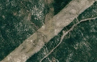
I first found about about Churchill Falls when a couple of years back I was panning a Google Map in Satellite view and noted this strange diagonal line all across Labrador. It was bizarre - what could it be? I traced it northward and found the Town and hydroelectric plant and became fascinated.

Google Street View of the huge swath of the  transmission lines
View >
Google Close Up Aerial View
View >
The red line indicates the transmission lines wide swath across Labrador


Crater - René-Levasseur Island

Did you know?

The Manicouagan Reservoir and René-Levasseur Island are sometimes called the "eye of Quebec".

The geological structure was formed by the impact of a meteorite 214 million years ago. It is the fifth most powerful known impact that Earth has seen! The shock wave and air blast from the impact severely damaged and killed plants and animals out to distances of approximately 350 miles. Some scientists believe that this impact may have been responsible for a mass extinction associated with the loss of roughly 60% of all species.

Google Maps
https://www.google.com/maps/@51.455296,-68.5609973,126744m/data=!3m1!1e3

Manicouagan Impact Crater from Space: by @NASA, 
International Space Station Expedition 59

Manicouagan Impact Structure

The force of the impact exhumed and liquefied rocks down to as deep as 9 kilometers.  The heat released was so intense that it took between 1,600 and 5,000 years before the melted rocks cooled.
http://craterexplorer.ca/manicouagan-impact-structure/