- Ritual beer binges
- Fake maps
- Free Love in the mid 1800s!
- Urine - a Roman Hygiene
- The Dutch had the hots for (?)
- and more...
Friday, April 3, 2020
History Quirks
Fun facts - a few bizarre and unique lesser-known historical tidbits of the past. Rain or shine, a good read!
Friday, February 28, 2020
Reservoirs East of the Hudson River
New York City gets it water from a variety of sources. Some of it comes from a series of reservoirs and lakes north of the city.
In 1905 the New Croton Dam was completed, expanding the existing area of impounded water.
History of the Water Systems
As the population of New York City grew in the 19th century, so did the need for water. The first use of water from Westchester County came from the old Croton Dam (forming what was called Croton Lake), which was completed in 1842. In the 1880s, the City faced increasing demands for water and therefore needed to enlarge the Croton Reservoir to meet that need.
The enlargement of the Croton Reservoir (with the construction of the New Croton Dam and the forming of the New Croton Reservoir) was completed in 1906 as a part of a system of reservoirs designed to bring water from Putnam and Westchester Counties (the Croton Watershed) to New York City. It is called the New Croton Reservoir because the Croton Reservoir was actually the name of a made made reservoir right in the heart of Manhattan - Link.
Cross River Reservoir
The Cross River Reservoir was put into service in 1908. The resulting body of water is one of twelve reservoirs in the Croton Watershed, the southernmost of New York City's watersheds.Titicus Reservoir
The Titicus Dam was constructed between 1890 and 1895 and the reservoir was placed into service in 1893.The Croton River
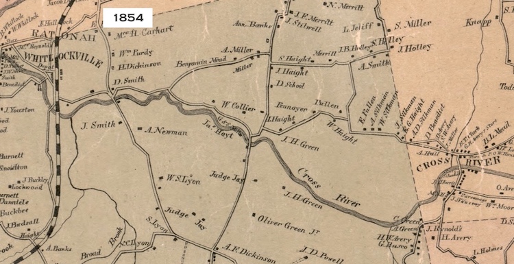
As you can see from this 1858 map, what is now inundated with large large bodies of water was just a simple river system back in the mid 19th Century,
The Croton Reservoirs today...
Muscoot Reservoir
The reservoir was completed in 1905 and serves as the main collecting point for all the reservoirs in the Croton Watershed (except for the New Croton Reservoir, which later receives its water).New Croton Reservoir
The New Croton Reservoir is the collecting point for water from all reservoirs in the Croton Watershed. In 1842 the Croton River, a tributary of the Hudson River, was impounded by the Old Croton Dam to create Croton Lake. It was New York City's first source of water beyond its city limits and its waters traveled by aqueduct to the Croton Distributing Reservoir in midtown Manhattan.In 1905 the New Croton Dam was completed, expanding the existing area of impounded water.
Sunday, November 24, 2019
Hidden Crater in the Catskills
Did you know about the "crater" in the Catskills?
The circular pattern made by the two creeks surrounding Panther Mountain suggest that it might have a different origin from other Catskill peaks. In the early 1970s, a geologist of the New York State Geological Survey at the New York State Museum in Albany wondered if the stream pattern indicated an impact crater buried beneath the surface.The impact is estimated to have occurred 375 million years ago, during the Devonian period, when much of what is now the Catskills was either river delta or a shallow sea. The crater lies 2,640 feet below the surface, is 6 miles wide, and lies directly under the mountain. The meteorite that struck is believed to have been roughly one-half mile wide, striking with a force equivalent to 11 trillion tons of TNT. -Wikipedia
Further Info
Is the U.S. Better Off As A Bunch Of Separate Countries?
Food For Thought
- Should the U.S.A. have a "velvet divorce,” (a reference to the 1993.peaceful dissolution of Czechoslovakia — now the Czech Republic and the Slovak Republic)
- Has the U.S. has run its course and need breaking up?
Article >
Saturday, November 23, 2019
Mapping America's Loneliest Roads
Fascinating Study
A study which crunched 2015 annual average traffic data from the Highway Performance Monitoring System to find the least traveled roads in each state, and in all of America is now online as interactive map.Interactive Map >
The Soviet Military Secretly Mapped the Entire World
Interesting article!
In the early 2000s, a shop in Riga, Latvia’s capital held bundles of Cold War-era maps of British cities, created by the Soviet military
The Russian maps were supposed to be destroyed after the fall of the Soviet Union, but some officers, seeing an opportunity for profit, sold them. They have never been officially declassified. “Russians won’t talk about them, the people who created them will hold their secrets to the grave.”
In the early 2000s, a shop in Riga, Latvia’s capital held bundles of Cold War-era maps of British cities, created by the Soviet military
The Russian maps were supposed to be destroyed after the fall of the Soviet Union, but some officers, seeing an opportunity for profit, sold them. They have never been officially declassified. “Russians won’t talk about them, the people who created them will hold their secrets to the grave.”
![]() |
| Central Park, NYC |
Article >
Thursday, September 12, 2019
How Human Activity Is Changing Animal Migration Patterns
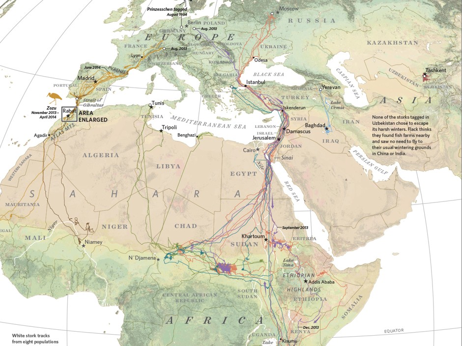
Humans have long tracked the movements of animals by following their paw prints or staking out their natural habitats. That kind of observation still has its value today, but now biologists also benefit from a slew of satellite, radio, and GPS technologies that can track the digital footprints of, say, a herd of elephants or a flock of storks as they move across the globe. And at a time when both climate change and urban development are changing—and disrupting—the migration routes, there’s a new urgency in these kinds of research.
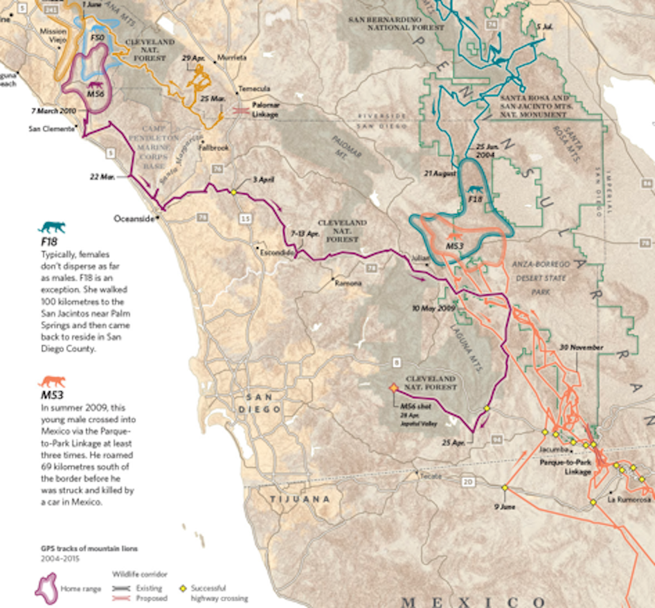
In southern California, mountain lions are in decline in part because of the expansive freeways that crisscross the state. When researchers tagged a sample of lions in Santa Ana with GPS devices, they found their natural habitats divided by as many as eight lanes of traffic, as well as houses, golf courses, and other private developments.
Despite proposals to build animal crossings after the fact, over- and underpasses have proven ineffective; they’re rarely used by the big cats. The risks go farther than just ending up as roadkill. The roads themselves become cages for mountain lion populations, isolating various groups and resulting in higher rates of inbreeding. This threatens their growth and survival as a whole.
In southern California, mountain lions are in decline in part because of the expansive freeways that crisscross the state. When researchers tagged a sample of lions in Santa Ana with GPS devices, they found their natural habitats divided by as many as eight lanes of traffic, as well as houses, golf courses, and other private developments.
Despite proposals to build animal crossings after the fact, over- and underpasses have proven ineffective; they’re rarely used by the big cats. The risks go farther than just ending up as roadkill. The roads themselves become cages for mountain lion populations, isolating various groups and resulting in higher rates of inbreeding. This threatens their growth and survival as a whole.
Full article at Map Lab:
Its a fascinating read...
Subscribe to:
Posts (Atom)