Saturday, December 12, 2020

Three Great Interactive Maps

A Few Great Interactive Maps...

With technology advancements, content on maps and the maps themselves became digital, interactive, and more appealing as they’re incorporated in data analysis and reporting. Seeing location data mapped and included in visualizations has both enhanced understanding by more audiences and offered a valuable, new context.

Below are three notable data-driven examples that demonstrate the power of location data when paired with business intelligence.

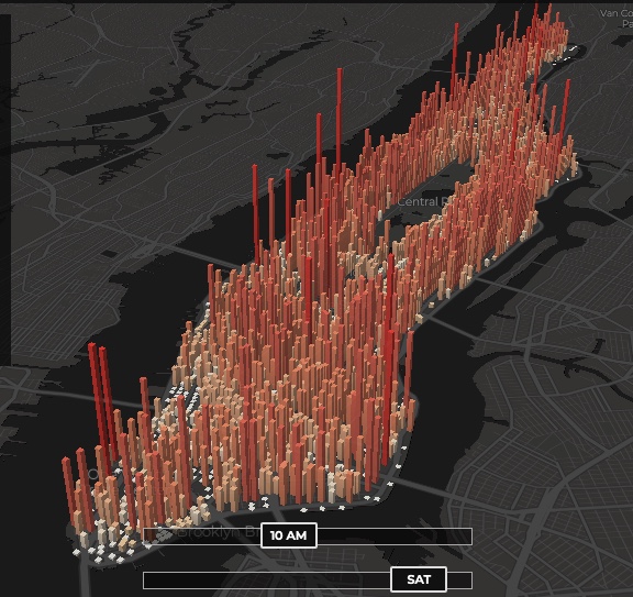
1 - The invisible heartbeat of New York City

Visualization by: Justin Fung. This is amazing (you may have to refresh the page)

http://manpopex.us/


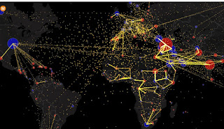
2 - All the World’s Immigration Visualized in One Map

Estimated net immigration (inflows minus outflows) by origin and destination country between 2010 and 2015.


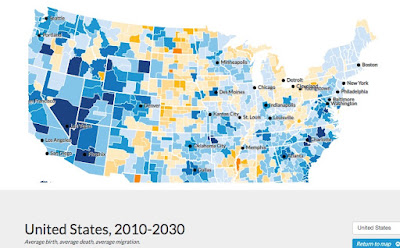
 3 - Mapping America’s Futures

This is a great example of a well made data-driven interactive map.

Test possible scenarios for how the US population might change by 2020 and 2030. The results will change depending on whether you choose low, average, or high rates for future births, deaths, or migration.

https://apps.urban.org/features/mapping-americas-futures/#map


Friday, December 11, 2020

Maps That Show Us A New Perspective

This is an interesting site! The blurbs with each map are short and well written as well....

Land Use Throughout The United States

Air Traffic Control Zones Look Nothing Like The Country

Metric System Vs. Imperial System

Texas Doesn't Look All That Big Next Compared To Africa

Maps That Show Us A New Perspective >


Saturday, December 5, 2020

Ghost Towns of the World

This a phenomenal site! Navigate across the world using a Google Map that links to a myriad of wb sites on ghost towns, etc.

Ghost Towns of the World


Map location links will take you to sites with photos such as these:

Tuesday, November 17, 2020

US Westward Expansion and "Manifest Destiny"

What was Manifest Destiny"?

Manifest destiny was a widely held American imperialist cultural belief in the 19th-century United States that American settlers were destined to expand across North America. 

Historian Frederick Merk says this concept was born out of "a sense of mission to redeem the Old World by high example ... generated by the potentialities of a new earth for building a new heaven". However, in contemporary culture many have condemned manifest destiny as an ideology that was used to justify genocide against Native Americans.

Historians have emphasized that "manifest destiny" was a contested concept—Democrats endorsed the idea but many prominent Americans (such as Abraham Lincoln, Ulysses S. Grant, and most Whigs) rejected it.  Wikipedia 

"Our manifest destiny to possess the whole of the continent."
-attributed to Newspaper editor John O'Sullivan in 1845 

Manifest Destiny - the 19th-century doctrine or belief that the expansion of the US throughout the American continents was both justified and inevitable.

1872 painting "American Progress" by John Gast
Book Cover
Satirical Pictorial Map Depicting Westward Expansion, 1828
Source

The Transcontinental Railroad

Nevertheless despite Lincoln's reluctance in endorsing manifest destiny,  the U.S.'s First Transcontinental Railroad was built between 1863 and 1869 to join the eastern and western halves of the United States. Begun just before the American Civil War,  the Railroad Act of 1862 put government support behind the transcontinental railroad and helped create the Union Pacific Railroad, which subsequently joined with the Central Pacific at Promontory, Utah, on May 10, 1869, and signaled the linking of the continent.

In obvious disregard to long-standing Native American settlement, railroad workers' wages were to be paid in land, thus ensuring that there would be settlers along the route to supply produce to and become patrons of the completed linkage. 

Shortly thereafter (starting in 1881) many other transcontinental railroads were built (the Southern Pacific Railroad , the Northern Pacific Railway, the Great Northern Railway, the precursor to the Santa Fe Railroad, etc.). These transcontinental railroads facilitated the colonization of western territories by encouraging new settlements on Indigenous lands.  In the process, Native Americans were decimated and the vast herds of buffalo were nearly exterminated.

"The Oxford English Dictionary defines colonialism as “colonization by settlement.” In the case of the U.S., Canada, and other settler colonies, colonialism was a process that replaced existing, Indigenous communities and ways of relating to the land with settler populations, and settler ways of life." The impact of the Transcontinental Railroad on Native Americans

1885

(by Rich Coffey from the album Nature Suite)

Sunday, November 1, 2020

NYC - Antique Maps

 Interest zoomable/pannable antique maps of New York City

Original 1859 Topography of Manhattan Island

This map, compiled from old Surveys and records, was intended to exhibit the general localities of the original drainage streams, without defining the precise points at which they would intersect the Streets and Avenues in 1859.
Author: Viele, Egbert L. - Date: 1859   View Interactive map at David Rumsey.com >

NYC - Battery to 80th St. -1859


Topographical Map of the City of New York 1865

The map shows all the original water courses of Manhattan Island, with the street grid superimposed on top. Three different kinds of land are shown: Marsh, Made Land, and Meadow.
Author: Viele, Egbert L. - Date: 1865.  View Interactive map at David Rumsey.com >

NYC Topo 1865

An aerial illustrated view of New York City 1931

1931 illustrated map  showing city blocks, streets, roads, railways, landmarks, buildings, parks, etc. Includes note on Rapid Transit facilities. Copyright Herald Square Hotel. 
Author: Herald Square Hotel Date: 1931 View Interactive map at David Rumsey.com >

NYC Aerial View - 1931

Friday, October 30, 2020

Native Lands (interactive map)

This is a fascinating Map

"View an online map that wipes away borders imposed by colonial powers to reveal a complex, colorful overlap of Indigenous territories, languages and treaties. Launched in 2015, the map draws on data from historic research, maps by Indigenous people, and ongoing input from people all over the world. Visitors can search for the roots of their own homelands and witness a view of the world that is almost never reflected on contemporary maps."

Native Lands - Interactive Map >

Note - it seems to not work with Chrome (try Firefox instead)


MapLab: Bearing Witness to Native Land

Related Article >

Friday, October 23, 2020

Native Americans - New Hampshire

Part 9 of an ongoing series on the history of Native American Territory as told through maps. This series is tagged as "Native American Map Series". It is recommended to visit all the Further Info links listed below for further study.

Native Americans - New Hampshire

For roughly 12,000 years, Indigenous peoples have lived where we now call "New Hampshire." The Abenaki tribe (together with the Maliseet, Passamaquoddy, Mi'kmaq, and Penobscot Indians), were members of the old Wabanaki Confederacy, adversaries of the Iroquois. These allies from the eastern seaboard spoke related languages, and Abenaki and Wabanaki have the same Algonquian root, meaning "people from the east."

The original inhabitants of the area that is now New Hampshire:

Source

There were three important subdivisions of the Abenaki tribe: the Sokoki (or Sokokis), the Cowasuck (Cowass or Coos), and the Missisquoi (or Mazipskwik.) 

Missiquoi Territory within the Larger Territory of the Western Abenaki Tribe

Although there is no local reservation or population center for the Native Americans, their names endure as names for modern-day cities, mountains and rivers:

  • Amonoosuc River ('manosek) – Western Abenaki for "fishing place."
  • Amoskeag Falls (namaskik) – Western Abenaki for "at the fish land."
  • Contoocook River (nikn tekw ok) – Abenaki for "to or from the head or first branch of the river."
  • Grand Monadnock (minoria denak) – Abenaki for "the bare or smooth mountain."
  • Kearsarge (g'wizawajo) – Western Abenaki for "rough mountain."
  • Massabesic Lake (massa nbes ek) – Abenaki for "to the great pond."
  • Merrimack River – Abenaki for "deep water or river."
  • Mount Pisgah – Abenaki for "dark."
  • Nashua– Abenaki for "two."
  • Sunapee Lake – Abenaki for "rock or mountain water."
  • Suncook River – Abenaki for "to the rocks."
  • Umbagog Lake  – Abenaki for "to the clear water lake."
Today
There are no federally recognized Indian tribes in New Hampshire today. Most Native Americans were forced to leave New Hampshire during the 1600's, when eastern tribes were being displaced by colonial expansion. The descendants of Indigenous populations who historically resided in New Hampshire can be found in several surrounding U.S. states and parts of Canada.